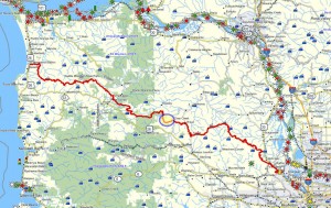
 Brief summary: This hike is located about midway to the coast on the northern route – on the north side of the Sunset Highway. It is one of the most remote sections of the trail system to reach – requiring a substantial hike up to the ridge where this portion of the Portland-to-Coast route is located. A logging road does reach the western end of this segment, but that road is not always open to vehicular travel. However, the trail itself is lovely – extending for most of its length along the top of a remote ridge line and affording views of limitless forests as far as the eye can see.
Distance: 2.1 miles of approach from Keasey and 4.2 miles along the ridge-top route
Walk duration: 2 hours 15 minutes (one way). Plan for a 7 hour trip, including the drive time, approach/descent and round trip along the route. If you’re like me you’ll want some time to dawdle along the way – that makes it an 8 – 9 hour outing.
Travel time to trail head: 1 hour and 10 minutes or 47.4 miles from the Sylvan interchange on Highway 26. Access requires travel to Vernonia and travel by way of the Keasey Road to the entrance to the Eastside Grade (at the end of Keasey Rd).
Elevation change: Total elevation change is 920 feet. The trail begins at the bottom of the Eastside Grade at an elevation of 920 ft. The summit of the ridge is located at about 1450 – 1600 ft. The highest point reached during this segment is about 1840 ft. Most of the route fluctuates along the ridge line at an average altitude of 1600 feet.
Trail Log: The trail begins at the very end of the Keasey Rd. A left hand turn takes you up about 400 feet to the gates that block vehicular traffic into this private timber land. Here’s where this hike begins at an elevation of 920 ft.
At the end of this approach road you will find a gate blocking the main access route (the Eastside Grade) on the left and another smaller road on the right. The route on the right climbs into the same hills but eventually circles around (via a very rough track) and rejoins the Eastside Grade further up the hillside.
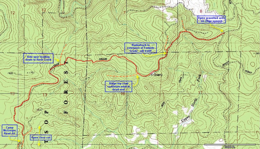
But we will proceed up the Eastside Grade which gradually ascends the northern slopes of these hills from whence Rock Creek and Fall Creek receive their waters. The roads begins in an easterly direction, but swing back around westwards within .6 miles. At this point we encounter a spur that veers off to the left. We stay on the right branch and soon the road turns to climb uphill in a southerly direction. Approximately 1 mile from the starting gate, we encounter a four-way intersection of well traveled logging roads that connect this ascending route to a transverse route that follows the horizontal lines of the hillside. Another 1/10 mile along we encounter another road that slits off on the left. This spur road eventually crosses the top of Rocky Point and connects with the road on the southern side of this hill. But we will stay on the main route and continue to ascend the slope to where it eventually crests the ridge line. There at the summit we will find a broad expanse of open area with a quarry tucked into hillside on the left.
At this summit clearing the road splits. One road designated as the “Eastside Grade” runs along the left side of the open area and crosses directly in front of the quarry. This road is the end of the previous segment of the Portland-to-Coast route which connects with the Rocky Point Road on the south flank of this hill, and it is the southern approach to these heights. Descending southwards by means of this road we can (via a network of logging roads) reach access gates on the Timber Road or at the entrance to the Clear Creek area.
On the right side of the open area at the summit is another road (sometimes designated as an “unknown road” or sometimes confusingly also called the “Eastside Grade”) begins to gently ascend the southern flank of the rising ridge to the West. This is the beginning of the next Portland – Coast segment that we have climbed up to reach. All the foregoing 2.6 miles of climbing the Eastside grade has merely been to reach the East end of this segment of the Coastal access route.
Follow this unknown road along the southern flank of this hillside for a half mile. As you approach a tall stand of trees the alders begin to crowd into the old roadway as it traverses the hillside. Keep a sharp eye out on the left (downhill) side for a flattish shelf that parallels the road. It is very uneven and overgrown with alders, but easy enough to penetrate. If you find this shelf, you’ll also find an elk trail that traverses the slope using this shelf. A bit further on you’ll see that it’s actually the remains of an old road, and the foresters have built repeated berms and ditches to prevent the ATV crowd from re-establishing the link. If you can’t find the traversing the link, you can continue on up the trail. A short distance up you will pass under a tree that has fallen across the road. From here you can look up the road and straight into the the curve, as the road bends to the right. It is precisely in this curve that you will see faint traces of deer and elk traffic extending into the woods (to the left of the trail). Look further down as the deer track slopes over the edge of the shelf. There the elk and deer tracks make a clearly distinguishable track that descends the slope, and drops down into the trough formed by the original road (now blocked by berms and otherwise obstructed) that leads out to a cul-de-sac at the “end” of this portion of the Eastside Grade. Whether you find the elk trail or not, simply go straight when the road turns and then drop down about 50 yards and you can’t miss the road. Originally, it used to connect with the “unknown road” that you just walked up, but earth movement and a desire to cut the connection has severed a vehicular connection.
Once you have arrive at the lower road continue to follow it as it traverses the hillside. About 4/10 mile further along, this second “unknown road” arrives at an intersection with the western continuation of the “Eastside Grade”. This intersection presents 3 options. Directly ahead one road penetrates a forested slope and bends slightly to the right (curving around the flank of the ridge that we have been following). In the middle another well traveled road slips down the northern face of the ridge into a mature forested area. And finally on the left side, a more rudimentary track follows the ascending ridge line – just outside the forest fringe. The middle folk descends along the ridge line, but ends a short ways on. We will proceed down the right option (clearly the most traveled route) and follow the Eastside Grade as it slips around the ridge, through a small clearing and then descends among the trees heading generally westwards.
We will traverse this segment of the Eastside Grade as it winds along the ridge line, at one point rising to an elevation of 1840 ft. After about a mile the road begins to descend the southern flank of the ridge line as we proceed roughly westwards. After 1.8 miles from the last (ridge-top) intersection the Eastside Grade emerges from the forest into a clearing from which three other roads diverge.
Approaching the clearing from the northeast, we enter a Y intersection where the Eastside Grade is joined with the “Pit Road” approaching from the southeast. Immediately to the west of the Y intersection the road enters a clearing in the woods. What appears to be the main road crosses that clearing and heads westwards along the ridge line. On our right the Lower Rock Creek Road branches off and heads north to follow Rock Creek to a cul-de-sac about a half mile above where we originally left the car at the end of Keasey Rd. Here the road ends and no longer connects with the trails originating from Keasey Rd. However, it should e noted that there is fine little quarry just up this road that provides deep pool of cool water just suitable for people and dogs to find refreshment.
The main road that crosses the clearing heading westward is the continuation of the “Eastside Grade” and we will continue to follow this route for another 1.5 miles. This road is also referred to as the Camp Wheeler #2 Spur Rd. After a mile and a half the road comes out on the shoulder of a ridge with a clear-cut area sloping off to the southeast. On this narrow ridge top the road splits. The left hand option leads down Nofo Road, which ultimately reconnects with the North Fork Wold Creek Rd ultimately leading down to US 26. We will avoid this route as it can be muddy and impassable by ordinary road vehicles.
Instead we will proceed along the main track that bends slightly to the right. This is the extension of the Eastside Grade/Camp Wheeler #2 spur road. As we begin to walk down this road you may notice a less traveled road descending down the slope to the right of the main track. This is an untended extension of the Olsen Road that climbs up Olsen Creek and parallels the Eastside Grade for the final portion of its ascent.
It is at this split in the road where Olsen road splits off from the main Eastside Grade track that this segment of the Portland-to-Coast route ends. The reasosn for stopping at this point are:
- clearing we just passed serves as a good place to park.
- it offers access to several potential hiking routes if you’re just wandering aimlessly, such as following Nofo Road, or exploring the rudimentary track that crosses the top of the aforementioned clear-cut.
- it is the point at which an ascent from Olsen Creek connects with the ridge-hugging segments of the Portland-to-Coast route that we have just traversed.


Hello there! This is my first comment here so I just wanted to give
a quick shout out and tell you I truly enjoy reading your articles.
Can you suggest any other blogs/websites/forums that cover the same subjects?
Thanks a lot!
Hi! This is my first visit to your blog! We are a
team of volunteers and starting a new project in a community in the same niche.
Your blog provided us beneficial information to work on. You have done a marvellous
job!