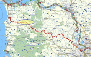
 Brief description:
This Northern Route trail segment is the second stage of a longer route that combines with the “Pope Ridge to Saddle Mountain” track to form a longer trek from Vinemaple to Saddle Mountain and thence from the shoulder of Saddle Mountain to Humbug Mountain.
Walk duration: 4 hours
Travel time to trail head: 1 hour 17 minutes (64 miles) from the Sylvan interchange on Highway 26 to the shoulder of Humbug Mountain – at the base of the track leading upwards through the trees towards the NW shoulder of Humbug Mountain. The pull off is located on the right side of the road exactly one tenth of a mile past the end of a double horseshoe bend – think “figure eight”). This trail is accessed from this western end, because the eastern terminus of the trail (where it connects with the trail leading west from Pope Ridge) is inaccessible by car.
Elevation change: 711 ft.
Trail Log: This trail segment begins at the end of the previous route that traces a 7.6 mile walking route from Vinemaple, located on Highway 103 alongside the Nehalem River to the paved Lewis and Clark Road that provides access to the popular peak.
In principle, the routes described on this blog have been chosen to eschew all heavily traveled roads, especially those that are paved for high volume vehicular traffic. But this short reliance on Lewis and Clark Road is an exception, since there are not real alternatives, and the portions of this route that rely on this paved route are as short as possible.
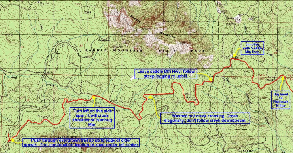
From this intersection of the Lewis and Clark Road and the logging road that approaches up the ridge from the east, the next portion of this route leads in a southwesterly direction down the paved Lewis and Clark Road. Follow the Lewis and Clark Road for .67 miles. At that point a logging road leads off to the right, climbing steeply up the southern flank of Saddle Mountain. The elevation at the base of this road (where it connects with the Lewis and Clark Road) is 1520 ft. Over the next mile this road climbs 220 ft in elevation. As the road levels off, a spur road is evident on the right, and later also to the right: a small quarry site.
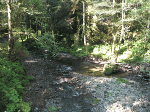
This ascent finally ends in a T intersection with a road running along the flank of the mountain. At the T intersection (1.47 miles from the start of this hike), turn right and follow this road as it heads west along the flank of Saddle Mountain. It skirts the top of a clear cut and then turns south and descends to intersect with another logging road 2.4 miles into the hike. The last portion of this road is lightly used and accessible only on foot, but it does come out on to a road that cuts straight through the forest and descends steeply from where our route abuts it at the upper end (1525 ft. in elevation) to its lower end at an elevation of 1260 ft. There the road turns abruptly to the left and the route becomes somewhat confused as it approaches a creek. There are several elk and footpaths that traverse this creek crossing, but suffice to say that the route continues on the far side of the creek –even though the route is not easily visible from the end of the road (2.9 miles from the start of this hike) you’ve just descended. Proceed towards the creek (1220 in elevation) and (3.25 miles into the hike) ascend the far side where the resumption of the route becomes visible again.
Follow this track down the slope, passing a spur on the right at 3.4 miles into the hike. A quarter mile onwards (3.68 miles) this track rejoins the Lewis and Clark Road. Turn right and follow this road down the Lewis and Clark River valley, crossing the Lewis and Clark River at 4.53 miles into this hike (elevation 1000 ft.) and later to where it joins with the Saddle Mountain Road. That junction is 5.75 miles into the hike (elevation 895 ft.); follow the Saddle Mountain Road to the left (southwards) and follow it for 1 ¾ miles to the shoulder of Humbug Mountain. At a distance of 7.5 miles (elevation 1300 ft.) look for a pull-out area on the right side of the road. In the woods behind it you should see a small footpath entering into the forest and (if you look through the stand of trees) emerging into a clear cut area beyond. This marks the beginning of the next installment of trail routes, known as the Ridge Runner’s Delight Trail – that ends the “northern route” in Seaside, Oregon.

Wonderful website and hikes here. Thank You. I am leading a group of hikers on a version of your hike which will have us reach the summits of both Saddle and Humbug Mountains. Any suggestions or even joining us would be of great help
We will be hiking this coming Saturday January 21st, 2017
Keep in mind that the north side of Humbug Mountain is essentially a shear cliff. I have checked my maps that are very detailed and none of the logging roads (that are accessible from the Humbug access road) connect to the Lewis & Clark River watershed. All the roads accessible from US 26 (entrance is just west of the summit) explore the various forks of the West Humbug Creek watershed. None connect with roads in the Lewis and Clark watershed, which you must cross to get to Saddle Mountain.
Also there is no feasible connection from the south face of Humbug Mountain to the Saddle Mountain access road that crosses the western shoulder of Humbug Mountain. I also do not recommend bushwhacking down the northern face of Humbug Mountain to reach the logging road that approaches from the north. The terrain there is a cliff.
Also at this time of year expect to find lots of snow making way-finding even more difficult and the danger of hypothermia (in case of an accident) more acute.
If I were planning this expedition, I would wait until late spring and then approach Humbug Mountain from the NE – hoping to find an undocumented skidder road, or new logging road that climbs out of the Lewis and Clark River watershed and heads in a SE direction. There are couple of places where (according to my topo, it would be possible to bushwhack from the Lewis & Clark River network of logging roads to a nearby road that traverses the top of the West Humbug Creek watershed. Once over the ridge (NE of Humbug Mtn) you will enter the West Humbug Mtn watershed – find any logging road in that watershed and work your way south to US 26. That would be how to find a feasible connection.
My suggestion is to attack the problem by climbing up and out of the Lewis and Clark River watershed in a SE direction. It’s easier to find hikeable routes when you’re ascending. If you try this descending from the eastern flank of Humbug Mountain you could easily find yourself stranded on a narrow ridge with cliffs all around you – better to explore going up such a slope. Believe me I’ve done this the wrong way and am lucky to have survived several bruising falls and terrifying cliff descents – don’t tell my wife!
In that regard, I would also recommend making this a 2-3 person hike, with everyone well aware of the difficulty of what you’re attempting. Be prepared to declare defeat if the going gets too tough. My rule of thumb is to explore carefully in order to establish a route that is not too dangerous, is clearly marked, and won’t outrage your more risk aversive friends. Despite that caution, there are a mere handful of brave souls that will accompany me on these explorations, and I usually expect to be “defeated” at least twice before I find a way through.
I’m currently doing this with the long neglected and untraveled Belding Road that descends down to the Salmonberry River from Roger’s Peak. So far it’s 0:1 in favor of mother nature. It will take me a few more tries and I may get it surveyed by August of 2017. It’s more about managing risk than getting to your destination.
Jim
Was reading about the Astoria & Columbia River Railroad in The Northwest’s Own Railway (Walter R. Grande, 1997; Vol I & II are at the Washington County Library, Cedar Mill Branch). I talks about the attempt to build a railway from Astoria to Hillsboro that was to go up the Lewis & Clark River to the Nehalem Valley and thence to the Tulatin Valley. It ran out of money at the end of the 1800s. But not before completing 17.5 miles of track up to the Lewis & Clark / Nehalem divide, and started in on a 1,530 ft. tunnel at 1,087 feet of elevation. About mid-way along this hike, it follows that divide (the bottom of square U just about in the center before decending into the Lewis & Clark watershed). According to the book, the remains of the incomplete excavation were still visible behind some bushes. This has to be pretty close to where this trail first crosses the Lewis & Clark river (going E to W). Are you aware in any more detail of where that is?
This is new information for me. I know the general area, but was unaware of the RR tunnel. Will have to do some bushwhacking to see if the remains are still visible.
Anyone else out there know anything about this track and tunnel?
Jim Thayer