
Although I have been collecting materials about early Oregon coastal trails and paths for many years, I was pleasantly surprised to find some original historical research compiled by Robert Benson in 1981. It included this unusual map and this uniquely expansive list of significant trails.
I have presented this map and the associated list with as few editorial (italicized) additions as possible. I can’t say I know more than a handful of these putative trails, but nonetheless I publish them here in part to preserve the record, but also to see if I can conjure some of you out there to respond if you have something interesting to add to the record. Maybe we can coin a new term and call it “crowd researching”.
Here’s Robert’s nicely drawn map: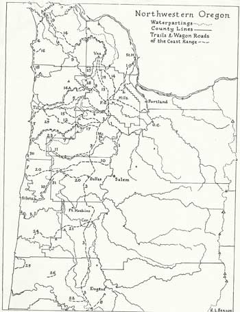
And here is his list of the various trails:
Indian Trails:
1. Jason Lee Trail, used by missionary searching for a location for his mission.
2. Logie Trail, Fort William Bend on Sauvie Island to Glencoe.
3. Klickitat raiding trail, perhaps same as fur traders’ main Westside route.
4. Ecola Trail, used by Captain Clark’s party going to see whale at Cannon Beach.
5. Pafaan Trail, from Patton Valley via S.Saddle Mtn and Hembree ridge.
6. Tualatins’ steelhead trail to Trask headwaters (from Trail Street in Gaston?)
7. Nenamusa Trail, rumored in use by Tillamooks for vacations and honeymoons.
Explorer’s Trail:
8. Dr. Elijah White’s route from Spencer Butte to ocean via Siuslaw River.
Military Routes:
9. Astoria-Plains Military Road, scouted by Lt. Geo. H. Derby in 1855
10. Doak’s ferry Road, by which cannons reached Siltz (or Forts Yamhill, Hoskins?)
Settler’s Routes:
11. Cattle trail, over which herds were driven to Tillamook and Clatsop farmland.
12. Harris Trail, gave Tillamook access to civilization in all weathers.
13. Cape Horn Wagon Road, west of West Dairy Creek and on to Vernonia.
14. Washington County, Nehalen & Astoria Wagon Road of 1873
14a. Wilson River Stage Road, Gale’s Creek (Gale’s City) to Tillamook.
15. Trask Toll Road, North Yamhill to Tillamook via Fairdale Mineral Springs.
16. Elk Creek Toll road, Cannon Beach to Necanicum River.
Major Hiking Routes, now usable at least in part (in 1981, when this list was compiled)
17. Big Nestucca logging road, unsafe but favored by bicyclists and hikers to the coast.
18. Oregon Coast Trail, planned throughout; officially open at the north end (much more since this was published).
19. Linear trail, on defunct United Railway grade; held up by local opposition.
20 Dallas – Coast Trail, planned along old logging roads; possible for equestrians.
21. Corvallis-Coast Trail, mostly for hikers only, in part for bicyclists too.
22. Eugene – Coast Trail, begun by Boy Scouts; frustrated 10 miles out.
Long Trails Planned, or in use in the 4 major proposed wildernesses.
23. Mt. Hebo Trail, planned to join the Three Rivers and Central Nestucca.
24. Drift Creek Trail, behind Waldport, planned as part of 21 above.
25. Coast Creeks Trail complex, gives views of unique coastal wilderness.
26. Windy Peak Trail in small wilderness between Deadwood and Lake Creeks.
Short but outstanding Scenic Trails:
27. Wolf Creek Falls Trail, with possible extension along Highway 26.
28. Low Divide Trail, joining gale’s Creek Forest camp with Wilson River Stage Road.
29. Munson Creek Falls Trail, through sub-tropical rain forest.
30. Hart Cape Trail, steep but scenic, just north of Cascade Head.
31. Valley of the Giants Trail, access to grove of near champion Douglas Firs.
32. Sutton Creek trail, with a special viewpoint for the handicapped.
I would like to add other trails like those connecting the Tuality plain with Willamette Falls, those trails along the Gorge that bypassed the treacherous rapids, trails along the Nehalem River, the Salmonberry River trail and the traditional crossing routes for the Cascades in Oregon and Washington. But I will leave this entry as un-embellished as possible.
Instead of offering my commentary, I invite you, dear reader, to add your observations! Please comment if you have updates on any of these routes. I also have updated information, but will offer it up elsewhere as we gradually refresh the details of the trails mentioned therein.
Jim


Can I get a sale map with grid lines/coordinates of your exciting places to hike/bike/explore?
Thank you. Oh I can pay for it.
Colette
The best way to get you the info you need is to download a .gpx file to you. That way you can load it on your gps device and follow the electronic trail. Tell me which ones from the website you want and i’ll “clean-up” some of the tracks I have on file (omitting all the side trips one takes on any walk) and make thenm available for download.
Jim
I will soon be publishing a page where you can acquire and down load maps, pdf’s and the text of the hikes. Stay tuned.
I’m getting ready to put a whole bunch of maps up for sale shortly. We’re switching to a new commercial “engine”. Jim
Thanks Jim! Perhaps make me a package? I am interested where previous towns/homesteads were, and any former places of little known or no significance. Thank you
Colette
PS perhaps a scale version with grid? U know like the universal markings?
Thanks Jim
I am so glad that I found your site! I am seeking information about Logie Trail and Morgan Road as well as Rainbow Lake. Robert Benson maps are outstanding, where can they be found? Any information you can provide or point me to would be great!
I have an article written By a Dr.Barry in 1929*, on the history of Logie trail. I think he was a professor at the local college in those days. I found it to be very interesting, I can scan and pass it on ( I think I know how) if you like.
*name and date cited from memory,
therefore may not be exact…I do have access to info. though.
Melissa
I would love to see this article. I am always searching for new historical material and it’s amazing how much is out there nestled in with the other paper’s from Grandfather’s desk…
You can reach me at jim@thayers”dot”org
Sorry about the longest time before my reply. I will scan and copy by email. However- It may take a few -or many times. My email doesn’t send large mail. I’ll see what I can do, may be bit by bit. I appreciate your patience, I don’t get online much during the summer-I’m outside. will put Logietrail in “subject” space… MAJK2000
Dear Melissa,
I would love to see this article. Please forward it to me at brittaduncan@comcast.net. I have also been in contact with Karen Lange of the Washington County Library who has located a few article about Logie Trail as well as a Robert L. Benson 1965 map. Any information about Morgan Road which is just on the other side of the lake is helpful, too. Thank you so much for responding.
Will get the article to you sometime soon. Sorry about the time taken to get back to you. My email not so good with large mail..may need to go a bit at a time. I’ll have logietrail in “subject” box. Thanks for being patient, MAJK2000
Like the map. What do the numbers, cept for the townships n ranges stand for? Thanks Jim
Colette
I frankly don’t know.
Jim
Hi Jim I work for ODOT Right of Way Office as the Files Coordinator. I am assisting the GEO- Environmental Office on Hwy 26 near Humbug Mountain. We have an old 1932 when we first got the Hwy from Clatsop Co. T5N R8W Sec 17, 21-27 shows a trail wandering next to the Hwy from Nehalem River (Sec 17) Saddle Mountain SP to the ranger station at (Sec 25). Do you have a trail name that is possibly in your wanderings? Map 1A-1-29 Anything would be appreciated Francis
Did you find the information you were seeking? Can you send me that 1932 map? email it to Jim@thayers.org