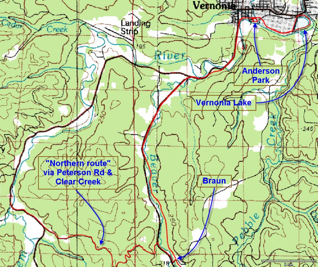
Distance: 8.25 miles (Braun to Vernonia Lake and back to Anderson Park trail head)
Walk duration: 3 hours 15 minutes
Travel time to trail head: 1 hour and 8 minutes (40.5 miles)
Elevation change: 50 ft change in elevation
Brief summary: This last segment between Braun and Vernonia is practically flat. The trail initially runs through the woods, but emerges alongside Route 47 as it crosses Beaver Creek. Then it parallels route 47 past the intersection with the Timber Road and on into Vernonia. This segment ends in Anderson Park located in Vernonia (5.66 miles), but I’ve added the short loop (3.4 miles) around Vernonia Lake to this segment.
This trail is described beginning in Braun, but it could just as easily be started at Anderson park in Vernonia – so that you can go into town for a coffee of beer after the long hike.
Connections with Portland to Seaside Trail: This segment of the Banks-Vernonia Trail also passes a critical juncture on the Portland to Coast trail. From McDonald Road, one has to take Route 47 north .56 miles to Peterson Road. Follow Peterson Road up .17 miles to get to the blue gate that marks the edge of the publicly accessible timber lands. This segment is described elsewhere as part of the Portland to Seaside trail route.
Connections with the Scappoose to Vernonia Linear Trail: Finally, this trail will soon connect with the Scappoose to Vernonia Trail currently under construction by Columbia County. Also in this same collections of linear trails, I describe the various segments of the new linear trail system built on the old Crown Zellerbach road.
Trail Log: This segment of the Banks to Vernonia Trail begins at McDonald Road in the hamlet or area called Braun. Aside from the label on the map nothing else suggest this place is Braun, but nonetheless it’s where McDonald road climbs the eastern slope of this valley and crosses the Banks-Vernonia trail near Route 47. There is not much space for parking except along the road. If you’re just walking this segment you might consider starting the hike from Anderson Park in Vernonia which has ample parking ($4.00 fee for longer than 20 minutes). or further north at the Beaver Creek Trail head.
The first two miles of the trail continue along the side of the hill just above the valley floor where the occasional homes are located. After two miles the trail crosses Beaver Creek, the location of another trail head. From here the trail parallels the road quite closely. Three quarters of a mile onwards (total distance: 2.75 miles) you cross a small lane. At this point you arrive alongside the junction of Route 47 and Timber Road. This side road veers westward from Route 47 circling a line of the hills to rejoin US Highway 26 at the Timber junction.
But our route alongside Route 47 continues northwards, bending eastwards as we approach Vernonia itself. Another three-quarters of a mile onwards (total distance: 4.57 miles) the trail and Route 47 cross the Nehalem River. After a total of five and a half miles we climb a slight incline and turn right into Vernonia itself and almost immediately we arrive at Anderson Park  (total distance: 5.66 miles) situated alongside the Nehalem River to the south of the main street.
If you wish to proceed further continue along the path. Just beyond the park, the bicycle and pedestrian path crosses a small footbridge. Keep following this path as it swings to the right and (total distance: 6 miles) rejoins the Nehalem River. This path eventually comes to Vernonia Lake and circles it bringing us back to Anderson Park in a 2.6 miles loop. From Braun to the lake and back to Anderson Park is 8.25 miles.


The name BRAUN for that area is because Johann Braun (my grandfather) was an early settler there (1880), raised his family of 2 sons (one was my father) and 2 daughters on site and was a postmaster for Braunsport, OR from 1891 to 1901. I grew up there and graduated from Vernonia High School. More information is available in the OREGON GEOGRAPHIC NAMES publication of the Oregon Historical Society page 93.
Bill:
Thank you for the background details. It is hard unearthing the old stories that bring these places to life. I cannot express my appreciation adequately for you and all the others that have come forwards with these valuable details that form the quilt of history. Do you remember details of growing up in Braun? Stories tell that the cougars were plentiful in this area, even frightening the soldiers send to build the military road through this area. Any stories passed down about the Calapuyans?
Jim Thayer – always digging for a bit more light to shine of these early days…