
Mud is us!
 If you spend much time squelching through Oregon’s soggy landscapes you might get the feeling that we have only recently squeezed from the primordial mud. And that might not be too far off, if you permit me to readjust your watch to count eons instead of minutes.
Less than a complete eon ago, just a mere 400 million years ago, during the Oligocene period Idaho had a lock on the best tropical beachfront property in the Northwest, but demand was a bit sluggish since only a few ungainly amphibians had actually waddled ashore to discover the benefits of terra firma. Instead the real action was in Oregon, which was covered by a subtropical sea and dotted with corral reefs. These warm waters were teaming with whimsical life forms. Jellyfish floated aimlessly in the waters, worms squirmed through the silted seabed, centipedes marched stoically across the muddy ocean floors and trilobites sporting fancy ribbed carapaces dominated the social scene for more than 350 million years. But as our emerging continent migrated slowly northwards cooling water temperatures would soon introduce new species like starfish, cuttlefish, bi-valve clams, horseshoe crabs, sharks and primitive vegetation on land.
In the meantime, the mud that I mentioned earlier was continuing to flow unabated into the shallow sea covering the eon’s worth of discarded trilobite carapaces, the remains of the myriad centipedes and the near infinite squiggly-wigglies that perished in that tepid bath that covered our present-day Oregon. Baked into the primordial muck for eternity these caked layers sank quietly into the earth’s crust. But here and there the stresses and jostling of the earth’s skin would force one of these long-buried layers to the surface to reveal a crowded catacomb of early protean life.
For those with the feet to discover these troves and the eyes to discern them, many of the North Coast mountains’ moss-covered outcroppings serve as remarkable windows into an antiquity beyond comprehension to most of us. The vicinities of the Sunset Highway are rich in paleontological evidence of this long-ago era in which mud itself was both the stimulus for life and the coffin to which it was confined once the shallow seas in Oregon dried to become the basis for our current muddy existence.
 That said, my best find was not a crumbling mollusk, but rather an old report issued by the Oregon Department of Geology and Mineral Industries (DOGAMI) in 1957 and written by Margaret L. Steere. With that pragmatic certainty that characterized so our post-war years, Margaret begins her report with the incontrovertible assertion that “the Sunset Highway area…is famous for its abundant marine fossils of the Oligocene Age.” Why, of course, silly me for not immediately knowing that!
The oldest fossiliferous sediments found in Oregon, the Cowlitz formation, date back to the Upper Eocene, but in this region they are comprised mostly of conglomerates and sandstone that were deposited near the shores of the Eocene sea that covered our area. Settled on top of this layer, are the more interesting Oligocene marine formations. The first two sites to be recorded were located near the tiny community of Keasey (near Vernonia) and about .2 miles north of the small community of Pittsburg on US 47. This formation appears as a grey siltstone formation that reaches 2,000 ft. in depth and runs generally in a broad band from Keasey in the north to Cherry Grove (near Gaston) in the south.
The most accessible locations mentioned in the report include the following sites that are in close proximity to existing hikes that I have surveyed.
Site #2 is located .2 miles north of the community of Pittsburg on Highway 47. The Vernonia to Elk Creek trail cuts across the headland between the east Fork of the Nehalem River and the main stem of the Nehalem River as it turns northwards from Vernonia. On the DOGAMI map, it cuts horizontally from Site # 3 to Vernonia itself. Though not in walking vicinity of the Vernonia to Elk Creek trail, the Pittsburg site is mere minutes away by car.
 Site #3 is a short distance on foot from the Crown Zellerbach trail that parallels the county road between Scappoose and Vernonia. This stretch of the trail is surveyed and described as the “Elk Creek to Summit” segment of the CZ Trail.
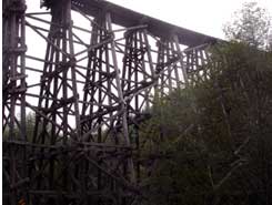
Just to the west of Hawkins Creek, the CZ trail runs parallel with the county road. It passes by a pretty log cabin set in a meadow on the south side of the county road. 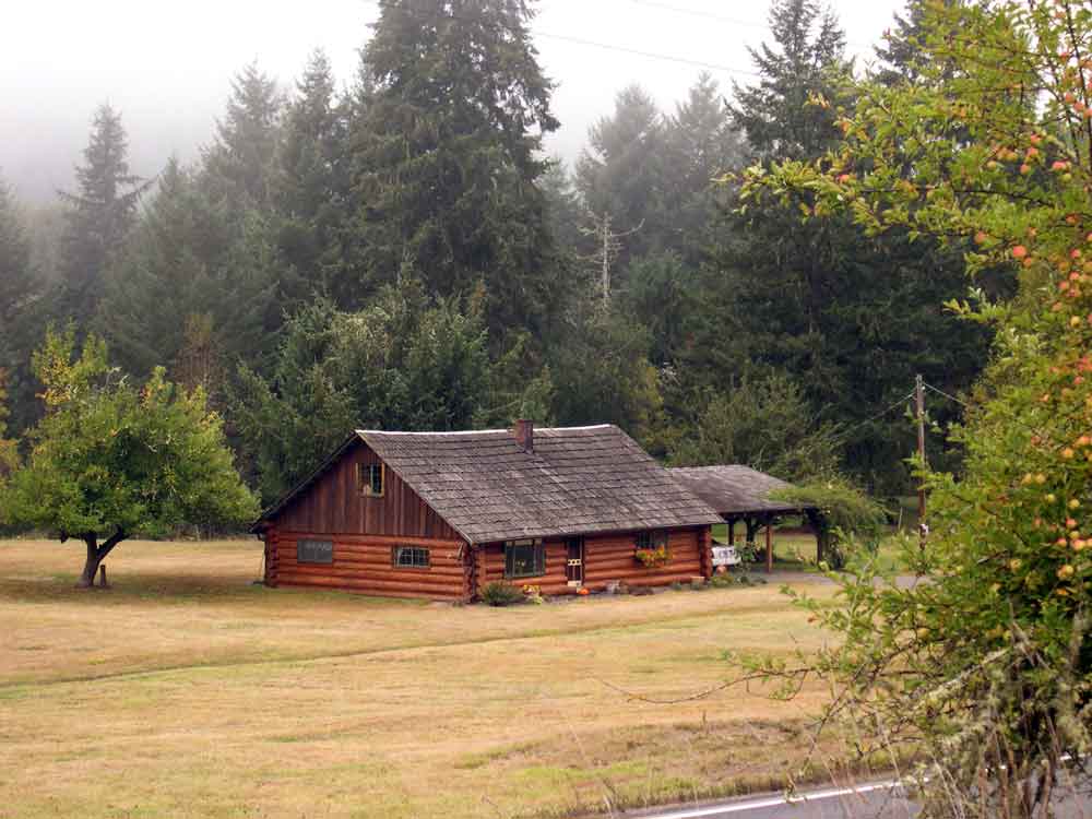 All along this gently descending slope look for outcroppings on the north side of the trail. This portion of the trail had several trestles as recently as the 1970’s, but they were removed after the development of the County Park at Scaponia. The
  1957 DOGAMI report indicates that the fossil beds are exposed for several hundred feet all along this portion of the trail. A short distance past the log cabin the county road and the CZ trail diverge, but before they split there is a gate that connects the two roads. From here it is a short walk along the county road to cross the bridge. At the west end of the bridge you will find another outcropping on a steep slope about 30 feet above the road.
Site # 4
This site is located near the erstwhile community of Keasey – which now is comprised of one house and a herd of elk. Keasey can be reached by traveling 8 miles from State Avenue and Highway 47 in Vernonia. The outcroppings occur on the banks of Rock Creek. According to the 1957 directions the best sites are located near the trestle that crossed Rock Creek to the Southwest of Keasey, sometimes referred to as Dead Man’s Trestle. The outcroppings occur near the water level on the low bank of Rock Creek, about 8.8 miles from Vernonia.
While this location is not mentioned in any of the trails surveyed, it is along the route that I frequently took to reach the East-side Grade and Rocky Point. If one goes to the gate at the end of the road beyond Keasey, a logging road ascends the east slope of the Rock Creek ravine. This route will eventually bring you to the Rocky Point quarry at the summit (DOGAMI site #5), from whence you can connect with the East-side Grade.
The rail line originally followed Rock Creek all the way to Camp McGregor near the Sunset Highway. However today it is difficult to follow the old rail line since much of this portion of the route was traversed by trestle, and once removed there remained no passable grade to follow. I have descended Rock Creek from above, but even on the west side of the Creek the track is quite obliterated and the terrain is too steep to traverse without significant struggles.
Site # 5
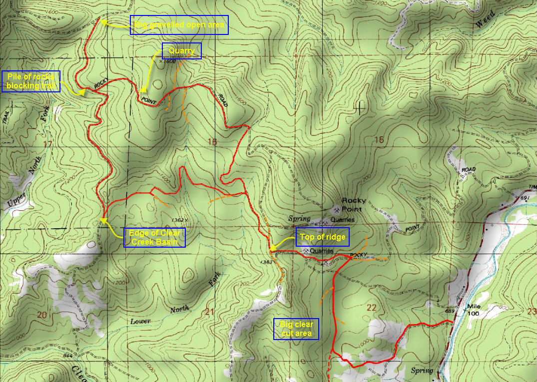 This location is a quarry located on Rocky Point to the west of the Timber Road leading north from the Sunset Highway to Vernonia. From the attached map of the Rocky Point to East Side Grade Trail, you can see that this area has a number of quarries and the description is unclear as to which of these it is. The area can be reached from the Timber road, as described in the “Rocky Point to East Side Grade” trail description.
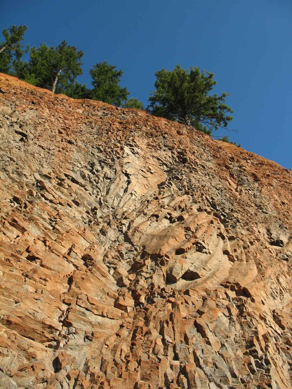
Near the juncture with the East Side Grade is a quarry (marked on the map, as “quarry”) that features a spectacular basalt formation that shows the beauty of the folding that can sometime rearrange the basalt strata into amazing designs.
Site # 6
Another fossiliferous outcropping of the Keasey formation occurs in a prominent cut along the Nehalem River on the east side of the road from Timber to Vernonia, 3 miles north of the junction with the Sunset Highway. Large pelecypods were reportedly found at this site.
Site # 7
 Both ends of the Dennis L. Edwards tunnel were originally cited as being good locations to reach the underlying shale beds that contained the fossil-bearing outcroppings, but since it’s the tunnel’s construction in 1940 weathering and grass plantings have degraded the soft shale causing it to disintegrate. In 2002 the tunnel was repaired, and the cuts into the hillside have been further landscaped obscuring the underlying fossil beds.
Site # 8
 Another location mentioned in the 1957 report is at either end of the high curving rail road trestle that crosses Highway 47 about 6.2 miles north of the Sunset highway. This location is located very close to the Banks to Vernonia trail, which is described in the “Stub Stewart to Trestle” segment of the Banks to Vernonia Trail. According to the DOGAMI report the site is noted for the presence of fossilized crinoids. To reach the outcroppings follow the Banks to Vernonia Trail from the nearby parking lot up the tracks and follow them out to the trestle. Along the way you can locate the fossils in the exposed outcroppings along the tracks.
Site # 9
Further south there are further instances where the Keasey formation is exposed. On the road that connects Timber to the Gales Creek area is an excellent exposed fossil bed. This Keasey formation crops up in a prominent cut at a sharp bend in the Timber-Glenwood road. It is located 1.3 miles south of the railroad crossing in Timber or about 5.2 miles from Glenwood.
Site # 10, 11 and 12
Three further sites are mentioned in Gales Creek area, at a quarry on Scoggins Creek road and finally on the north side of Cherry Grove road. This is also the area of known Indian Petroglyphs along the embankments of the upper Tualatin River, near the Richmond Hill Bridge.


i am intrested fossil
i,ve lived in vernonia as a child and return to hunt fossils there found a mammoth tooth off the nehalem river and i found a huge snail broke in half 12 inches by 5 inches plus tons of agate and fossil crabs its the best place i,ve ever hunted becuase you always find more than you can carry
Thanks for the confirmation of the fossil rich areas.
i m hoping to go do some fossil hunting with my kids in vernonia, where’s an easy place to get to to find some cool things (actually, anything would be cool for them!)
There are several places noted in the blog – such as near the trestle on 47, but others have said that combing the banks of the Nehalem is also good near Vernonia.
best place is at the base of the Rocky point quarry. Fossilized shark teeth are pretty cool there. Also Vernonia is known for these sand ball fossils that when you crack them open are full of sea worms.
Would you ever consider walking in with me to inspect the quarry. I’m not a rock hound, but would love to learn at the hands of someone more experienced than I.
Jim Thayer
Not sure about when it’s open. I usually walk in. Jim
Could you help me out? I want to take my class and I want to see fossils.
Do you have any suggestions of areas, which sites do you think are the best?
Carolyn
Since I am not a rock hound myself, I’m checking around. I also welcome feedback by others and will post them as they are submitted. Jim
where do you go when you hunt for fossils near vernonia (as precisely as you can–exp for critters, not leaves)– want to take a school group up and don’t want to take that pre-trip to check it out as in finals week myself! Thanks Tina
I pulled several fossils from the small bluff above Rock Creek across from the wading pool when I was a child and lived near there.
Oligocene period was not 400 million years ago as you state in your post. I think you meant Ordivician period.
Anyone know if they lock Rocky point regularly anymore and how crowded have the mainlines been?
Oligicene = 23-33 my ago
400 my ago would actually be the Devonian
There is no such thing as “a mere” 400 million years
I am living in mcminnville now and go back to vernonia to hunt and find that lot’s of people are going there now so that the fossils and rocks are getting very hard to find kinda being over fished , there are clubs that take large groups down the rivers and creeks now and well leave noting but dust behind, I have moved on to other ares where I can still find stuff and the age of fossils from that area are 50 to 20 million years old , and all logging roads are gated and they give fines for removing any rocks or fossils and clear creek is a big no no, logging companys are just plan greedy, they will never issue a permit I tryed 20 times and turned down ever time.
March 20, 2014 Went to Vernonia yesterday. Went on out Highway #47 to Mist. Got all the clam shell fossils i wanted. Found Keasy up a beautiful valley north of vernonia to the left 12 mi. Found fossil bank at Pittsburg. Found 4 coffee cans or wonderful banded carnielian. there was lots of jasper. I leave it, love agates. Found no sharks teeth or arrowheads. Note: I did have to jump a muddy roadside ditch to get the fossils which i could see from the highway side. From Portland, west hy 26 through tunnel. Next intersection is Timber junction and i go north toward Vernonia looking for mud cliffs—easy map with locations great. Thanks.
Glad I could help. I may publish a more detailed guide soon.
Jim
Hi Jim I went through the rocks that were collected along the Nehalem River near Vernonia and Keasey. In my last post I stated my disappointment in not finding any sharks tooth fossils. Well———-one of my agates is a piece of an agate replaced fossil clam. Jim, thank you for your encouraging posts. This is a permanent part of my collection. Wow!!!! I am going to try the Scappose Vernonia Road next.
Evening, in from the Nehalem River at Big Eddy park. The river is muddy and full bank to bank—no rocks visible. I used the extra time on location to acquire landowner access permission. Permission was granted to their property after a one hour of the landowner’s rock collection. I showed him last week’s marine fossils and he informed me that the fossil bearing location was his property also and I was welcome to collect there also. He said, “I don’t think we are going to run out in our lifetime.” It pays to meet the owners. Only a quarter coffee can of agate today so gathered grey striped jasper.
Fossil nodules in yard. There is s line of nodules at this point. They were evidently removed from the nearby slide area. lat. 45 degrees 58′ 43″N long. 123 degrees 11′ 20″W You can see them a bit on Google earth or punch in and drive. This location is on highway #47 near Mist. When you see this source, you will realize that these fossil banks are everywhere along Hy47. Look for shale banks for different age fossils. I collected a chalcedony clam two weeks ago from the river. Remember that this fossil bed goes clear to Gales creek. Marine fossils galore. There are great white clam fossils near Timber Junction off of Hy.26 The roadside banks are sliding with the recent rains producing great product. There are enough to leave the crummy ones for the flatlanders. I want sharks teeth and mammoth bones not white clams, search on. Here is a link to tectonic plate movement real time. http://www.geodesy.cwu.edu/data/wusdaily/
A source says my agate clam is a “Chalcedony pseudomorph after Clam” I want more specimens Agate fossils are in the river not the mud banks. I am going to try to locate the source of the agate (chalcedony) clams.
shark tooth found area #2 on Jim’s map I am excited. I first thought it was an agate but as I cleaned it I uncovered a nice tiger shark tooth. Thanks again Jim! I have a friend who will help post pictures soon. Jim’s site #2
This is my first time fossil hunting and I would like to take my nephew. I was wondering the exact address where we could park to go fossil hunting along the sunset highway. Thank you for any details you can provide.
Nick:
the best place to get information on geological and rock-hounding info in Oregon is probably the Nature of the Northwest store located in the state office building in Portland on 800 NE Oregon St., ste 965. They have some good resources, and pamphlets that cover where and how to go about rock-hounding. Their phone number is 971-673-2331. Also find them at info@naturenw.org.
Good luck.
Jim
Jim–
You out of Portland? Looking for a geologist to lead a group of kids….I’ve taken a geology class, but not the same as someone who has had years to “see” the land that way. I’m just beginning to see! Tina
Tina:
Yes, I’m out of Portland, but the problem is that I’m not a rock hound either. I would call DOGAMI to see if there’s a professional association they can put you in touch with. Jim
Found a single dentium out near the tressle along with tiny, fingernail pieces of shell. Will try some of your other locations next time. Thanks all! Hope to see those of you here in Beaverton, Hillsboro, OR area at the next NARG (spelling?) out at Rice Rock Musuem– call the museum to find out when the fossil group meets!
Last year I was scouting for the abandoned CZ tunnel, parked at the top of the pass on the Scappoose Vernonia Hwy (where the CZ trail goes beneath the hwy) and hiked back down the CZ trail towards Scappoose. My daughter picked up several accretions that were maybe five pounds each full of bivalve fossils and a few of what I think are cephalopod fossils. There were more there that we left behind.
went up hunting on a soggy Saturday in February and found clams and spiral shells, some agatized…couldn’t access the quarry. Good roadcut finds north of Vernonia en route to Pittsburg. Found the dig site behind the storage lockers and the lady there was very nice, but no fossils : (
Fantastic article – Thank you!
Great read with lots of leads, thanks! Planning on taking my 7 year old out fossil hunting to supplement his his already growing collection of marine fossils and agates 🙂 Any tips would be greatly appreciated. Thanks in advance!
Very informative article, thanks!
Hello James Rhoades, which article were you referencing in this post? I am looking for a better map or recent findings of fossils to go by. I will have my 8 yr old grandson and can’t hike very far, so I’d appreciate your suggestions.
Thank you!
Kathy
Ok after reading this i am very curious. I have been hunting rock for several years in the Nehalem rvr near Vernonia. A few years ago i found a rock that my friends and i jokingly called a sharks tooth. It looks likes a tooth but not from a shsrk, but because it looks neat i held onto it. Now i am curious as to what it might be
I’ve been rock hunting for years in the Vernonia area. I had read about 40 million year old turtle fossils that are inside what used to be mud balls and are nw refered to as concretions. This info. was from the university of Oregon. Years went by before I finally found one! and more mud balls since then with various contents. Well worth a day out in the creeks..even if you only find agates. Happy hunting..
I live out of Gaston and I’m curious whereabouts this geographic feature occurs into Cherry Grove?