
 Brief summary: This is one of my favorites trails that keeps pulling me back in all weathers. I have named this the “Barrow Trail” because of the huge pile of gravel that is located about midway along the trail – literally in the middle of nowhere. This artificial hill reminds me of the European burial mounds that can be found in England marking the grave of some ancient and forgotten king. Of course there are no “barrows” in this country, and the pile of rocks is undoubtedly a remnant from some prior road building effort. Nonetheless, I enjoy thinking of this curious hillock as a mysterious “barrow” hiding the remnants of some mysterious past.
 Distance: 6.82 miles
Walk duration: 3 hours 15 minutes
Travel time to trail head: 45 minutes (26 miles)
Elevation change: The trail starts at 1237 ft, and climbs to 1363 feet at the “Barrow”, before dropping down to to the ridge at 1180 feet in elevation. From this point overlooking the ridge we drop down to the road at 1059 ft, and continue down to the Binocular Point at 846 ft. Thereafter we ascend the ridge road for 687 ft – back up 1530 ft in elevation before leaving the road and dropping down onto the barrow trail – just as the the main logging road enters the older timber. From there we descend the Barrow Trail to the gravel pile and from there we retrace our steps back to the trail head.

The Google map shows that the road coming up from Dutch Canyon is called Otto Miller Road and at this intersection it turns into the forest and becomes a forest track. I have taken the liberty to rename this track the “Barrow trail”.
According to Google the road descending from Dixie Mountain is called NW Otto Miller Road.
Clear as mud, eh?
Trail Log:
The trail head for this trial is located on NW Otto Miller Road (elevation 1282 feet) just above two remote residences that sit atop the ridge surrounded by open pastures and beautiful eastward views. After passing these residences (if you’re coming up from Scappoose) the road enters the forest. Immediately upon entering the woods you will see a side road heading straight into the woods, while NW Otto Miller veers leftward. Enter this side road and park near the intersection with NW Otto Miller Road.
If you are coming down NW Otto Miller rd. You will pass the turn off just before you turn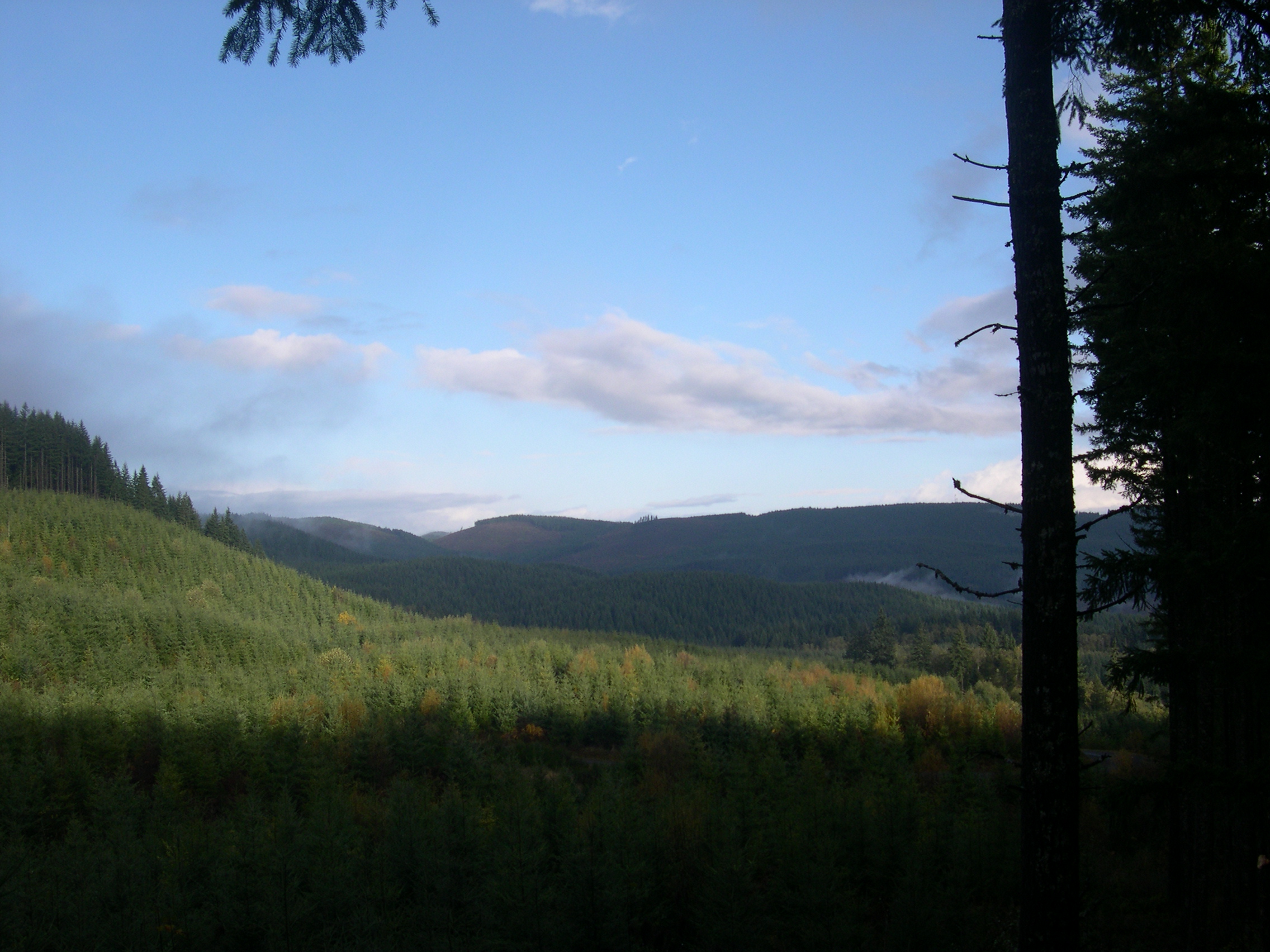 rightwards and emerge from the forest. Immediately ahead of you will be the first of two residences perched on the ridge top. The map and photo below show the turnoff from the perspective of a driver approaching from above, or from Dixie Mountain. Once parked, proceed up the dirt road. After 2/10th of a mile you will pass a yellow gate and a pile of rubbish near it. Some day I will go and collect this stuff.
The road is wide enough for four wheel drive vehicles, but I’ve only seen ATV’s and dirt bikes occasionally tackle this track. They like to use this route to get to the top of the hill. Our route will stay off the top of the hill and so we may be able to avoid these noisy mechanical hornets.
One word of precaution. In the wet season this road has patches of general “muddiness” with large puddles that have to be skirted. Boots are recommended, because running shoes may get wet in these conditions. If your dog is prone to mud baths, you might restrain him while on the actual Barrow Trail itself. The side trails are mossy and not so muddy. During the mushroom season, bring a plastic bag for gathering chanterelles, and the occasional white matsutake. I once found a nice big Cauliflower mushroom just off this road.
After passing through the gate the trail heads north-northwest passing through a young conifer woods and crossing a small creek (.3 miles from the trail head). Climbing up hill, the trail enters a stand of older trees. Here the trail turns abruptly to the southwest and begins a series of zigzags as the route weaves around the ridges separating the various headwaters of Lazy Creek. Eventually, the route turns in a northerly direction. Much of the slope is comprised of middle aged stands of Douglas firs and hemlock. The trail itself is covered with pine duff and moss, and surrounded on both sides by Oregon grape, vine maple and huckleberries. At various point trees have fallen on the trail, but they don’t impede travel much.
At .9 miles into the hike, the trail crosses the last stream. A small pond chocked with fallen trees and vine maple spills across the trail route. Crossing the pond’s outlet on pile of small logs, the trail turns eastward and upwards. Over the next third of a mile, the trail ascends about 100 feet in elevation. At that point it emerges into a small clearing dominated by a huge pile of gravel, probably left over from earlier road building efforts. But now it resembles some mysterious mound, perhaps marking the tomb of some log forgotten king, a “barrow” such as one might find in England. Hence I call this the Barrow trail.
At the “barrow” (1.2 miles) our path leads us to the right – immediately before the mound. As we walk alongside the southern edge of the hillock we emerge on to an older road moss covered track leading off into the forest. Mushrooms abound in this area including the delicious chanterelles and the even the mysterious but not edible Elfin Saddle. This long forgotten trail meanders through the woods ascending to the crest of this ridge (elevation 1345 feet) before descending in a northerly direction. Following this well marked but infrequently used trail for about .6 miles we drop about 200 feet to an altitude of 1166 ft elevation and eventually emerge from the forest onto the edge Dutch Canyon – about an hour into this hike. This area was harvested about 5 years ago and now sports a new crop of seedling aspiring to be Christmas trees, on their way to assuming the majestic dimensions of a mature Douglas Fir tree.
From this vantage point we get a great view of the upper Dutch canyon area, and we can see a road running down the south ridge. At the edge of the forest the trail looks like it ends, because brush and wood debris have been piled at the terminus of this sylvan road. You can circumvent this obstruction by detouring to the left where others have done so enough to clear a rough path. Beyond you will find a rough track of sorts that undulates dramatically from repeated mounds separated by deep dips in carved into the hillside to discourage ATV users from using this route. But this connection is relatively short, and you emerge on to the graveled logging road about 120 feet lower than the vantage point at the edge of the forests above you.
Walking down this rough track we see that it is awash with deer tracks. We will follow the logging road downwards, though the time constrained or tired hiker can immediately turn left and ascend this logging road to return more quickly.
I prefer to walk down the logging road for another 30 minutes following the ridge line and eventually taking the left hand bend to walk out on to a dead-end ridge-top that affords a beautiful view up the valley and down towards Scappoose. I call this Binocular point because it was here that I found a handsome pair of Cabela’s binoculars lying in the duff hidden behind the first line of trees that surrounded the end of this point.
When I first visited this isolated point (elevation 845 ft) the fog was rising out of the Canyon and the hillsides would reveal themselves in ragged glimpses before being swallowed up by the roiling mists. Above me the summit of Buck Mountain loomed about the vaporous canyon. To the South I could see all the way to the Canyon wall above which Otto Miller road ascends to the trail head. Below me South Scappoose Creek tumbles down the canyon. To the east of this point young trees crowd the slopes; to the west a clear cut affords unobstructed views up the valley. This is a nice lace for a secluded picnic except in hunting season when hunters abound.
Returning up the road, we pass the intersection (2.85 miles into the hike) that marks the downhill exit (elevation 771 ft) from this network of logging roads that eventually emerges onto private property alongside Scappoose Creek. We will retrace our steps uphill and avoid the long trek downhill that must eventually be retraced uphill.
In the past I have explored this lower road, but have not descended all the way to Scappoose Creek. The road heading downwards drops down to 755 ft. elevation and crosses Lazy Creek. The house over looking the canyon (located on Otto Miller road) is visible on the ridge top above. Following a track that diverges from the lower road I have climbed the slopes beneath the ridge that carries Otto Miller up the mountainside. A network of tracks ascend from this lower road to penetrate the steep hillside, but part way up the track splits and both end in a mass of blackberries and Scotch Broom. So I returned down to Lazy Creek and attempted to ascend the west side of Lazy Creek along what was once the original course for the Otto Miller road – this bushwhack was nearly impossible and just short of not survivable. Here is a memorable portion of the notes I recorded after stumbling through dense young conifer thickets to locate the remnant of the original Otto Miller road,
“The road turned out to be a virtual “Devils Club alley”: chocked with vine maple, burning nettles, logs, stumps, and wide swathes of nearly impenetrable windfall. Whip-lashed by branches, stung by nettles and torn by the Devil’s Club I struggled to follow the path to the headwaters of Lazy Creek where I knew the upper trail crossed the hillside.”
“I nearly had to give up where the old road traversed the Creek and began to ascend the southern slope of the ravine. The thickets of vinemaple and interwoven branches were so thick you could not force your way through . As I climbed up from the Creek I tried to ascend the ridge to get out of the dangerous patches of Devil’s Club. It was like climbing through a three dimensional Jungle Jim of branches, thorns and whip-lashing branches everywhere. Even Loki couldn’t get through. I finally succeeded and scrambling through the tangles and from there the only way was straight up the steep hillside. And it was wet, raining and we were getting very cold. And it was most discouraging. We scrambled bit by bit, stopping to catch our breath about every 100 yards. Finally we got to the very top. The top was just an utter thickness of Oregon grape and ferns. So soaked as we were, we got even wetter. But we made good time going up the ridge line and all of a sudden we came out on the Barrow Trail. And now I’m shuffling back to the car, cold and wet, but having succeeded in making one of the more difficult bushwhacks ever – straight up the Lazy Creek in the middle of winter…”
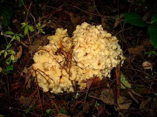
Sparassis Crispa – aka the Cauliflower mushroom
On this hike, we will ignore this lower road and return up the logging road which we descended, past the point where we entered from the forest track (3.22 miles from trail head) at an elevation of 1021 ft. We now follow this logging road for almost 1.5 miles up the Dutch Canyon towards Buck Mountain and it’s nameless companion on the southern side of the valley. At an elevation of 1352 feet, and 4.64 miles from our trailhead the trail turns southward and proceeds to climb into the older timber on the South side of this valley. At the very point (elevation 1352 ft.) where the road begins to enter the trees (4.88 miles) please reconnoiter the downhill side of the road. There you will spot an older trail that diverges from the active logging road. The direct connection from the current logging road is blocked by dense brush and a drop down from the existing road. There is no elegant way to navigate this rough transition to the top of the Barrow trail. I can only recommend that you visually locate the older road (below the current logging road) and scramble down to it in a manner that fits your style.
Once on the older duff covered forest trail, you can relax knowing that the rest of the way is downhill through the forest. At trail odometer reading 5.63 miles, a little less than a mile after we dropped down onto this older road, we emerge in to the “barrow” clearing and the big pile of river rock. From there onwards we simply retrace our steps along the hillside, recrossing the headwaters of Lazy Creek and eventually emerging back onto Otto Miller road, completing a round trip hike of 6.82 miles.


Thanks in support of sharing such a pleasant thought, post is good, thats why
i have read it completely
Feel free to visit my page data entry test – Elton,
I hiked this trail yesterday. Starting around the gravel pile, about a half hour into my walk, someone cut, and dumped trees on the roads. They did it in a way that was purposely done to make the trail impassable. I went on for a while, but it was too dangerous for me and the dog. leg breaker for sure. I saw no end in site too the impassable conditions.
Thanks for the feedback. I will go out and check it out.
Jim
I tried to hike this route last week. It started out beautifully but about 1 mile in I came upon a logging operation. The hiking path had been grossly widened by bulldozers and there was clear-cut all around, all ruining the nature experience. I pressed on for another half-mile but it was more of the same. Unfortunate turn of events for this route!