
 Brief summary: This walk is mostly on an older, rarely used logging road, but a portion of the trail traces a less defined road that has become partially overgrown – nonetheless the trail is fairly easy to follow as long as you’re not deterred by the occasional fallen tree, or infestation of shrubs blocking the path. The trail features the ruined remains of the Bob Johnston cabin that was maintained by the Boy Scouts for many years before it mysteriously burned down. The cabin once was the site of a ferocious gun battle between two bank robbers and a posse of locals.
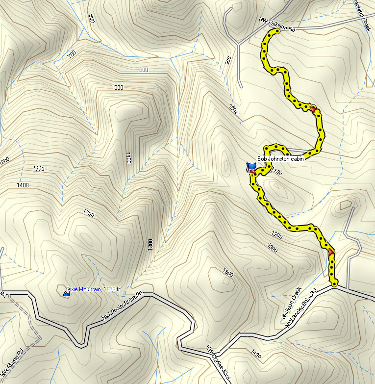
Jackson Creek Trail
Distance: 1.4 miles
Walk duration: 1 hour – round trip
Travel time to trail head: 35 minutes
Elevation change: The trail starts at 1221 ft, and drops down to 839 ft. as it rteaches Gilkison Road.
_______________________________________________________
 This trail is the linch-pin that connects the closer-in trails located on curved swath of hill sides from Burlington, past Cornelius Pass Road and Logie trail to Rocky Point Road, with the enormous forest range that begins to spread out in all directions above Scappoose. From here on the predominant feature of the land is uninterrupted forests, with occasional homes nestled in the verdant carpet that extends across the rest of NW Oregon.
Trailhead:
2.77 miles up Rocky Point Road from US 30 is the entrance to the Jackson Creek Trail. It is .45 miles below the intersection of Rocky Point Road and Skyline Boulevard.
Rocky Point Road is a very windy road, but near the top is passes through two clear cut areas. The first clear cut area is reached after a particularly tortuous set of twisting curves. The second clear cut that we pass through is another 1/4 miles beyond this point. At this clear cut you emerge into the clear cut and immediately see a blue gate on your right. Another gate is visible just beyond it on the left. At this point you’re entering a left bending curve with a young forest growing on either side of the road. At the very edge of the clear cut on your right is a private driveway heading directly north. Immediately beyond that in the curve of the road is another “blue gated” forest trail heading directly north. This is the trail head. There’s plenty of room to park your car near the gate.
Beyond the gate the trail heads due north, heading gently down  the slope for 1/10th of a mile, before bending leftwards and continuing on in a northwesterly direction. At this point you will pass a less used side trail that climbs the hill to your left. This is a short spur road that dead-ends further along the slope.
Keep a sharp eye open along the verge of the forest as you continue, as I have occasionally found chanterelles along this part of the trail.
Log Cabin: Continuing in a generally northwesterly direction for a half mile (from the gate) you eventually enter a cleared area at an elevation of 1125 ft. At the north end of this clearing you will find a ruined log cabin set amongst the trees. The cabin bears a plaque to commemorate Bob Johnston who  evidently built and cared for this idyllic cabin, which belonged to came Boy Scout Troop 221. Local folklore has it that the place was subsequently used by a drifter. Neighbors eventually chased the drifter out after nearby residences experienced increased pilferage, but during the unwelcome resident’s departure the cabin mysteriously burned down.
Tucked into the woods nearby is the remains of the log cabin outhouse which still stands as a mute testament to the beauty and endurance of log cabin construction.
Descent to Gilkison Rd:
After examining the remains of this once beautiful cabin, and wondering whether the obvious evidence of reconstruction means that it will someday  be rebuilt (I have no answers to this), we turn back to the road and proceed downhill. The road now takes a series of bends, with a short spur leading out to a clear cut area .1 mile below the cabin. But we will stay on the main road as it curves back around and passes below a clear cut slope. This is an area much frequented by deer, elk and even cougars. Here is an example of a cougar foot print found on this stretch of the road. Keep in mind that I have never actually spotted a cougar in all my hundreds of solo walks, and there has never been a recorded cougar attack in Oregon. So there is no need to be afraid.
As we continue down the trail through the aforementioned “S” bend, we emerge at the base of a small clear cut hillside. The path runs along the bottom of this slope and appears to disappear  into the bushes at the far end. But just continue on past the shrubs and young trees that partially block the path and you will emerge at a ‘T” in the path. The right hand option turns uphill, and a slightly less distinct left hand path descends the hillside. The upper path traverses the hillside for a while before getting lost amongst the private tracks belonging to a residence to the east of Jackson Creek.
The “T” intersection is about .3 miles below the cabin at an elevation of 1000 feet, and we want to take the lower road and descend parallel to Jackson Creek, which you can hear coursing through the underbrush on your right. The initial portion of the trail is partially obstructed by overhanging branches and shrubs, but gradually the trail turns northward while dropping to 940 feet in elevation. About .2 miles down the trail flattens out and crosses a seeping water source that creates a lush area of vegetation, and in the winter creates a muddy spot to cross. After about 300 feet of relatively flat ground the trail once again dips as the trail turns to NNW. All along this trail you will encounter brush and fallen alders obscuring the trail, but just continue to press onwards and you will be rewarded as the path reasserts itself turning in a westerly direction. Another 300 ft onwards the trail turns back to its original NNW direction and begins dropping from 900 feet in elevation to 840 feet in elevation as it emerges at the green gate on Gilkison Rd.
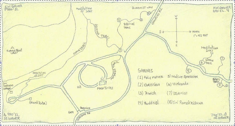
From here one can go on and visit the Vedanta Society’s property and tour their unique collection of shrines, including the awesome Native American Shrine.


Hi Jim,
It was a lovely day today to find this trail, but our 2 attempts were unsuccessful. However, we did enjoy the sunshine and the views of the mountains. So many blue gates! We just couldn’t figure out the right one.
Cheers,
Angelita
I grew up just a few houses (1/2 mile) down the road from the retreat. I have fantastic memories of stroling those woods as a child. It is a magical spot with suprises to find in the nooks and cranies. Thank you for posting this, it has brought back many pleasant memories for me.
Shalom,
Emily
I stumbled on your blog a few weeks ago and purchased your most recent book, which is awesome! My husband and I hiked to the Vedanta retreat last weekend, and decided to visit the old Sophie Mozee homestead. We can assert that the trail has indeed become extremely overgrown; in fact, in quite a few places, the trail disappears completely. We never did see an option to turn right and go back up the hill, as the trail naturally turned to the left. Our legs are still stinging from all of the underbrush covering the trail, but no matter! We had an amazing hike (with not a single other soul on the trail… bliss!), and will be back to do it again… this time with longer pants on. Thank you so very much for documenting these trails! We are enjoying our explorations immensely.
Please post a comment on the amazon page for this book. That would help get the word out. Jim
Just hit this up today, good shout. I’m wondering if this site is still active.
Yup still active. Jim
Went to this trailhead. There is a “Private Road” sign posted on the gate. No Weyerhaeuser signage.
Try starting from Gilcrist road, just before the entrance to the Vedanta retreat. Look for a green gate on the left (uphill) side of the road. See instructions for Vedanta Shrine hike on how to get to Gilcrist rd. I also mention this green gate in that hike . Jim
Hey Jim, I just stumbled across this and I am curious if you’ve heard of an abandoned town called Idiotville, somewhere out by salmonberry, I believe? The only info I can find is that there is a mine perhaps, and a trestle, and that it is quite a hike. Rumors are that it is found from an access road before salmonberry rd. I need a new adventure very badly right now, thank you!
Gwen
You know, I think I have come across a mention of Idiotville, but I can’t find it. I checked Ralph Friedman’s In Search of Western Oregon, as well as a bunch of histories of the early logging – to no avail. Suspect you need to pursue this through the mining connection. Many of these obscure mining towns have been reduces to nothing more than a trestle and a few rotting logs where once a lean-to sheltered the miners. I’ll keep on looking, but not sure of ultimate success.
Jim Thayer
Jim,
I’m happy to see this account is still active. I am currently reading your book, which I’m really excited about, but having a hard time with the maps. I’m wondering if you’ve ever recorded GPS tracks or waypoints for these trails? It sounds like others have encountered overgrown or otherwise not easily navigated routes/paths. I’m interested in completing all of them this spring (for context, I live in NE Portland, am a seasonal trail worker at Mt Rainer, have a lot of backcountry and backpacking experience, and have done a few thru hikes – but generally always have the routes marked in a map on my phone via Avenza or Gaia). Let me know if you have or if this is an endeavor you’d like to collaborate on.
Loved your episode on OFG!
-Hadley J., NE PDX
You can download the relevant GPX files for each of the trails, and yes some of them are pretty gnarly. Many of them are what remains of trails cut over 550 years ago! Need help call me at 503-860-3297