
This site explores surveyed and mapped walking routes from Portland to the Coast. The trails and the differing routes are broken into distinct segments and areas from which they originate.
The initial portions of this trail system linking Portland to the Coast are located in Forest Park and to the area directly north of the park – extending all the way North to Rocky Point Road. These trails were amply described in my book, Portland Forest Hikes, published by Timber Press in 2007.
The Salmonberry corridor focuses on those trails originating south of US 26 and roughly following the Salmonberry River to Nehalem Bay. It includes trails in the vicinity of Strassel Road, Timber, Cochran, Gale’s Creek and Roger’s Camp. This Corridor also includes some excellent trails developed by the Tillamook State Forest and located in the Wilson River Valley.
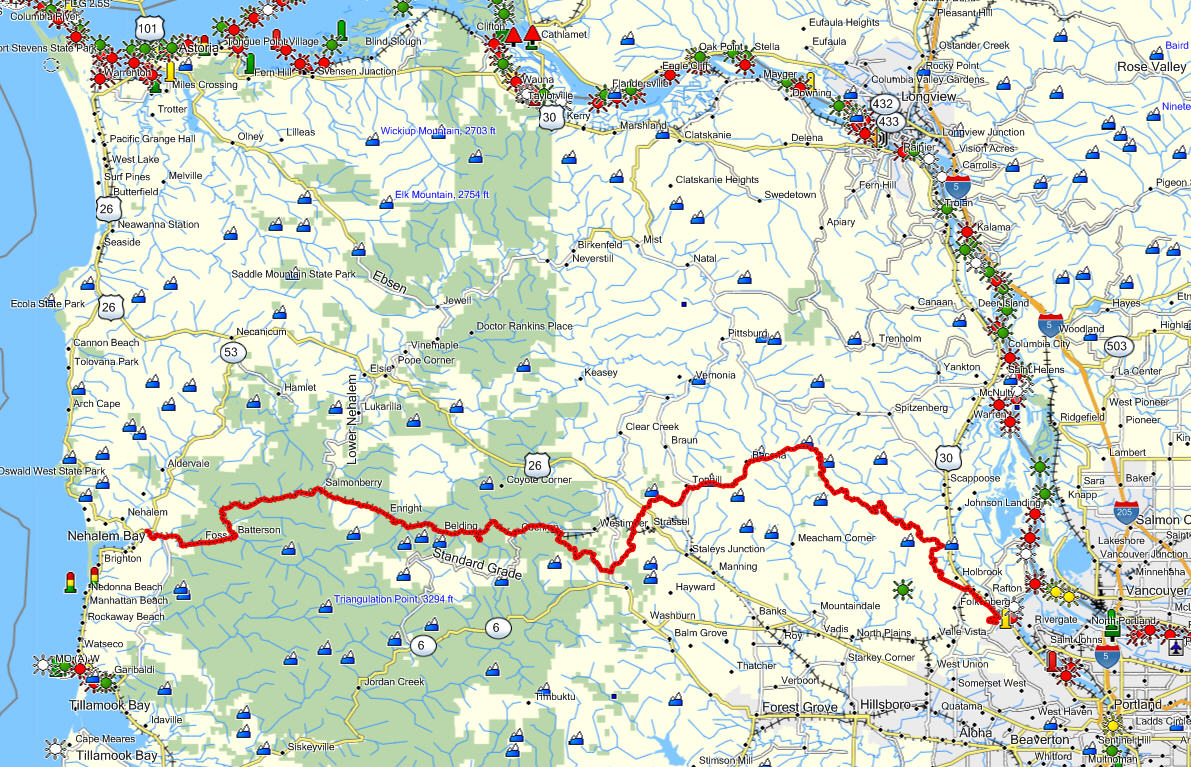
The map below shows the different corridors and the general alignment of the southern route to the coast which will use the now defunct Tillamook Railroad route.


I tried to pull up the map of the Salmonberry corridors but i’m greeted with ‘error- not found’. I’ve hiked some parts along the river but would love to venture the whole thing
Fixed it, I think. Jim
nevermind, i found it 🙂
Good, I hate fixing broken links…they keep me chained to my computer and not outside kicking up leaves. 😉
Looks like the link is broken again, can’t find the map
The site is optimized for mobile devices, but it appears that this software doesn’t support tabs and thus does not permit you to find the map using a mobile device or ipad.. If you access the site from a PC you should be able to see it. Yes, this is something that will get fixed soon.
Jim
Hi Jim,
thanks to your inspirational work, efforts and publishing, I am now planning to hike from my doorstep in Portland all the way INTO the Pacific. I decided to take the Salmonberry Corridor you have suggested. Which route, in your opinion, allows for the best ‘wild’ camping opportunities along the way? I plan to spend no more than three nights on the trail.
Peace.
I would agree that the Salmonberry offers more opportunities for wild camping. Official locations along the way include:
* Scaponia Park in Columbia County
* Stubb Stewart Park in Washington County
* Reeher’s Horse Camp near Timber
* Gales Creek Campground on Highway 6
* Spruce Run located on Foss Rd near the confluence of the Salmonberry and the Nehalem rivers.
I doubt you can cover the entire stretch in 4 days, but trying is half the fun… Jim
Jim,
Saw Oregon Field Guide on program on your hiking to the coast from Portland, which mentioned your website. I’m not able to open the map showing the Salmonberry Corridor using my PC. Any suggestions?
Many thanks,
Mike
Anyone else having this problem? Jim
Jim,
I can’t even see the link for the map!
When I opened the Salmonberry Corridor page this message in the top left corner (rectangle-shaped box on a rust-colored background) appeared and remained: “Fatal error: Theme CSS could not load after 20 sec. Please download the latest theme at http://galleria.io/customer/
I didn’t try to download anything but perhaps this message can help figure out the problem?
Jewel
Hi, Jim –
So inspiring to see you hiking to the coast on OR Field Guide recently.
Could you provide a key to the colored symbols on the Salmonberry map?
Thank you
Loie:
I borrowed this map from one of my GPS software packages. The symbols along the Columbia River have to do with navigation, etc. and are irrelevant to our purposes. I chose this map because it reminds me of maps in the Hobbit, besides it has all kinds of funky place names, like Doctor Rankin’s Place and Timbuctoo. Many of the names of the smaller communities are useful in my wandering.
Jim
Im vary interested in this route. Have been planning a similar trip next month. Do you have a more detailed map by chance? or any advice/warnings?