| Distance: 4.24 miles one way; 8.5 miles round trip
Walk duration: 4 hours 30 minutes
Travel time to trail head: 45 minutes
Driving directions to the trail head: From downtown Portland drive north on US 30 to Scappoose. Turn left opposite the gas station on Bonneville Drive and then an immediate right on to Old Portland Road that parallels US 30 passing behind Scappoose. Turn left on Dutch Canyon Road, and follow this gradually west entering into the South Scappoose Creek valley. Follw this road all the way back to the bridge near the very end of the Dutch canyon Road. Cross the bridge and immediately after the pavement ends. Follow this dirt road upwards and pull off and park at the first blue gate on the left hand side of the road.
 Elevation change: highest elevation 990 feet; lowest 370 feet crossing Gourlay Creek Elevation change: highest elevation 990 feet; lowest 370 feet crossing Gourlay Creek
Conditions: graveled logging roads, some portions with rougher grade stone, but dry and hard all the way. Walkable in all weather.
Trail Description:
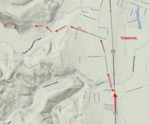
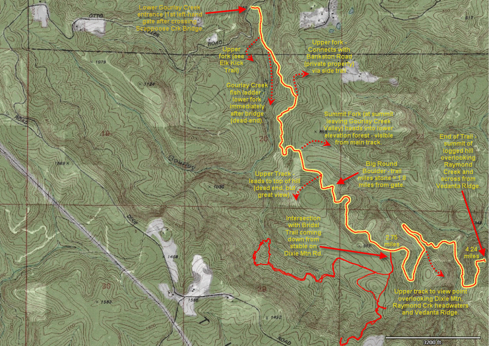
Begin your hike at the Gourlay Creek bottom gate. This is the first gate on your left after ascending the Otto Miller Road from the Dutch canyon bridge on the Dutch Canyon Road. This gate is .4 miles from the Dutch canyon bridge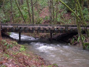 , and the bridge is .28 miles from the intersection of Old Portland Road and US 30 (as shown in the accompanying map). , and the bridge is .28 miles from the intersection of Old Portland Road and US 30 (as shown in the accompanying map).
From the gate (elevation 450 ft.) the road descends for .28 miles to 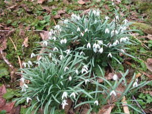 the Gourlay Creek Bridge (see picture) which marks the lowest point of the walk at 356 ft elevation. In March of the year you can find the Snow Bells blooming to herald in the coming Spring season (see picture). the Gourlay Creek Bridge (see picture) which marks the lowest point of the walk at 356 ft elevation. In March of the year you can find the Snow Bells blooming to herald in the coming Spring season (see picture).
It’s not hard to forget you’re in “loggin” country out here, because you’re likely to see the rough hewn humor of the woodsman mocking you from a tree that greets all the log trucks as they slow down to cross the wooden bridge into the Gourlay watershed. Nailed into the thick green moss that encases the hemlock trunk is bloody plastic leg – the kind you buy at practical joke stores that sell whooppee cushions. Holding it in place is a cast-off antler from which dangles a rubber mask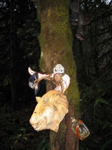 of some outlandish monster – visiting from one of the Starwars republics. The obligatory moonshine jug is fasted to the tree through the small glass loop at the neck of the bottle. An alarm clock rests atop this Freudian jumble of discordant images. This tableau is completed by the pair of ankle high lace up logging boots that dangle above this ridiculous collage as if proclaiming their musty seriousness about what lies ahead. of some outlandish monster – visiting from one of the Starwars republics. The obligatory moonshine jug is fasted to the tree through the small glass loop at the neck of the bottle. An alarm clock rests atop this Freudian jumble of discordant images. This tableau is completed by the pair of ankle high lace up logging boots that dangle above this ridiculous collage as if proclaiming their musty seriousness about what lies ahead.
In fact this “grade-line” road pushes resolutely through the broken forests and 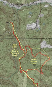 multi-folded hills and ravines leaving a wide swath of rugged gravel to mark the unhesitating purpose of its builders. It is as if the owner of the boots had triumphed over the whimsy of the grinning alien monster. multi-folded hills and ravines leaving a wide swath of rugged gravel to mark the unhesitating purpose of its builders. It is as if the owner of the boots had triumphed over the whimsy of the grinning alien monster.
Just beyond the bridge the road splits three ways. The main road marches directly up the hill. The left hand option wanders off down the creek side and gets lost among the bushes. The moss-covered road to the right follows the creek upstream for .4 miles before it arrives at a holding pond and fish 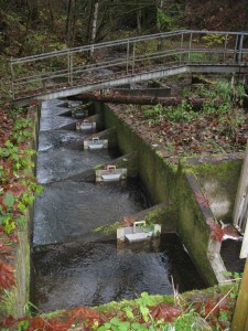 ladder. The Creek itself extends at least another mile, eventually turning in a northwesterly direction into a lateral valley that crosses the higher slopes of the Tualatin Range . We encounter these upper reaches on the Upper Gourlay Trail. ladder. The Creek itself extends at least another mile, eventually turning in a northwesterly direction into a lateral valley that crosses the higher slopes of the Tualatin Range . We encounter these upper reaches on the Upper Gourlay Trail.
But on this hike we will follow the main grade-line up the hill. For the next 1.1 mile this well worn dirt road pushes up the hill gradually climbing out of the Gourlay Creek ravine. About .75 miles from the bridge a lesser spur road splits off to the left and doubles back to ascend the ridge above this road. This route is described in the Lower Gourlay Trail Loop. About 100 feet before reaching this spur road heading up to the left, you can see a big patch of devil’s club growing off the shoulder of the road. Note the spiky thorns that adorn the branches. Try to avoid contact with this plant, unless you want to be covered with an itchy rash.
On this hike 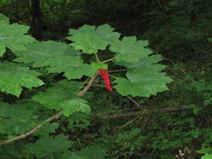 we bypass this spur road and continue on for 1.1 mile (from the bridge) until the road finally crests the side of the hill passing through a copse of tall fir trees to spill out onto the eastern facing slope of the Tualatin Range. Here the road splits with a spur heading off to the Northeast – this is part of the Lower Gourlay Creek Loop. The main branch of the road bends to the right and continues to climb, albeit more gradually than your ascent to this “summit” intersection. we bypass this spur road and continue on for 1.1 mile (from the bridge) until the road finally crests the side of the hill passing through a copse of tall fir trees to spill out onto the eastern facing slope of the Tualatin Range. Here the road splits with a spur heading off to the Northeast – this is part of the Lower Gourlay Creek Loop. The main branch of the road bends to the right and continues to climb, albeit more gradually than your ascent to this “summit” intersection.
Follow the main road southwards another .2 miles gradually climbing from the 810 foot elevation at the “summit “ intersection to 876 feet in elevation. At this point you will see another minor side spur leading up the knoll that rises above the road. We will ignore this spur on this hike, but this is the route you will want to take to connect with the Upper Gourlay Creek Trail (which ends just over the top of this hill). See my descriptions of the Gourlay Creek Upper Loop for further details on how to make the connection.
Just past this spur road, 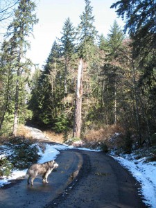 the road bends bends in the fold of the hill and doubles back to encircle the next ridge line. A large round boulder sitting on the side of the road makes an excellent landmark. This rock is 1.8 miles from the gate and is noted on the map above. But our way continues southwards parallel to the headwaters of Raymond creek which flowing along the bottom of the valley to our left. The road continues along at a fairly level rate for another .7 miles where it intersects with the road coming down from the Bridle trail. This road is described in the page devoted to the Bridle Trail. If you were to hike through from Dixie Mountain Road to Otto Miller this is one of two possible routes – and likely the only one that you can access without trespassing on posted land the road bends bends in the fold of the hill and doubles back to encircle the next ridge line. A large round boulder sitting on the side of the road makes an excellent landmark. This rock is 1.8 miles from the gate and is noted on the map above. But our way continues southwards parallel to the headwaters of Raymond creek which flowing along the bottom of the valley to our left. The road continues along at a fairly level rate for another .7 miles where it intersects with the road coming down from the Bridle trail. This road is described in the page devoted to the Bridle Trail. If you were to hike through from Dixie Mountain Road to Otto Miller this is one of two possible routes – and likely the only one that you can access without trespassing on posted land
Recently the land next to this junction has been logged, and you will soon see further evidence of active logging further on. At this point you may observe a greenish metal box mounted by the side of the road. This was used to fasten a cable across the road to restrict access to the points beyond. During my most recent forays along the Bridle Trail and this grade-line road I encountered fresh logging at this intersection and then at various points further into the watershed and beyond this chain-gate. Continue on and the road dips down into a little valley complete with a small pond and a huge deadfall stump. Flocks of finches like to frequent this sheltered nook and their gregarious chirping fills the air on most days. The road bends around and emerges on to a long ridge at an elevation of 730 feet. At this “ridge intersection” the main track turns left and follow the ridge line north.
An alternative route ascends the hill to your right. This road climbs the slope immediately above the ridge (about .8 miles to the end) to an elevation of 1076 feet – about half way to the crest of the hill, but the track peters out on a steep clear cut. Along the way there are two points that overlook the Raymond Creek valley and the east face of Dixie Mountain. If you wish to save yourself the 1.3 miles remaining to reach the end of the grade-line road above Raymond Creek, these view points (about .25 miles from the ridge intersection) let you appreciate the remote beauty of this place without going to the very end of the trail.
The main route to the terminus of the grade-line road heads north from the ridge intersection. It follows the ridge to its end and descends from 700+ feet to about 500 feet elevation as it doubles back and traverses the slope above Raymond Creek heading south. At this stage the road had previously washed out, but the logging has required the repair of this section. Finally the road turns and climbs the final peak to an elevation of 800+ feet on the final (recently logged) hill. When I first came here a few years ago this hill top was deeply forested and gave me little visibility across Raymond Creek to the Vedanta Ridge. Today, this barren hill affords good views of the surroundings. From the gate to this point is 4.3 miles; round trip the journey is over 8.5 miles long.
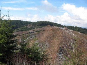 So having arrived in this remote spot, what can we learn or appreciate about this location? First, this is the east face of Dixie Mountain, a particularly remote place to reach and the site of not a few interesting tales from the beginnings of European settlement in the area. Situated immediately above this slope is the old Sophie Mozee homestead and her cabin that was built at the foot of Portland Hill – the height of land located immediately north of the intersection of NW Skyline Blvd and Rocky Point Road. This hillock was thus named because one could se Portland from its summit. So having arrived in this remote spot, what can we learn or appreciate about this location? First, this is the east face of Dixie Mountain, a particularly remote place to reach and the site of not a few interesting tales from the beginnings of European settlement in the area. Situated immediately above this slope is the old Sophie Mozee homestead and her cabin that was built at the foot of Portland Hill – the height of land located immediately north of the intersection of NW Skyline Blvd and Rocky Point Road. This hillock was thus named because one could se Portland from its summit.
One story told of this area is the tragic death of Albert Lange who walked more or less the same route we’ve just described from Dutch Canyon to Rocky Point Road. 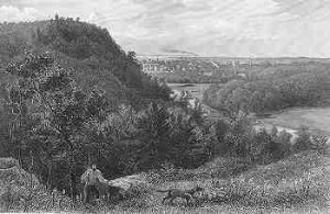 Hunting with his two dogs he had traversed this mountainous terrain encountering snow, thick vegetation, ridges and canyons, thickets and fallen trees. Most likely he would have passed close to this location before crossing Raymond Creek and ascending Vedanta Ridge. Near the end of the day he emerged from this trek on to Rocky Point Road, where he met Abe Cornelius, another of the original settlers on Dixie Mountain. Abe recommended that Albert take nourishment at his home before trying to return to Dutch Canyon, but Albert demurred. It appears that his dogs now treed a coon, which Albert shot and skinned. Later he was also able to kill a deer and dress it near the Mozee homestead before starting for home. The search party was later able to piece together his movements, which now clearly showed signs of fatigue and possibly hypothermia. Falling off a log he rolled down the hill in the snow, but he continued down the ridge further likely approaching the hillock upon which our route terminates. Eventually he fell in the snow and failed to rise. It is reported that when the search party finally located him a couple of days later the dogs were found with their noses in his arm pits as if trying to raise him out of the snow. Their loyalty in protecting their master complicated matters for the rescuers, but eventually they were able to separate the dogs from their dead master. Though there are few among us that would be able to traverse such a wilderness for 6-7 miles, the lessons of exercising prudence in the face of the elements Hunting with his two dogs he had traversed this mountainous terrain encountering snow, thick vegetation, ridges and canyons, thickets and fallen trees. Most likely he would have passed close to this location before crossing Raymond Creek and ascending Vedanta Ridge. Near the end of the day he emerged from this trek on to Rocky Point Road, where he met Abe Cornelius, another of the original settlers on Dixie Mountain. Abe recommended that Albert take nourishment at his home before trying to return to Dutch Canyon, but Albert demurred. It appears that his dogs now treed a coon, which Albert shot and skinned. Later he was also able to kill a deer and dress it near the Mozee homestead before starting for home. The search party was later able to piece together his movements, which now clearly showed signs of fatigue and possibly hypothermia. Falling off a log he rolled down the hill in the snow, but he continued down the ridge further likely approaching the hillock upon which our route terminates. Eventually he fell in the snow and failed to rise. It is reported that when the search party finally located him a couple of days later the dogs were found with their noses in his arm pits as if trying to raise him out of the snow. Their loyalty in protecting their master complicated matters for the rescuers, but eventually they were able to separate the dogs from their dead master. Though there are few among us that would be able to traverse such a wilderness for 6-7 miles, the lessons of exercising prudence in the face of the elements 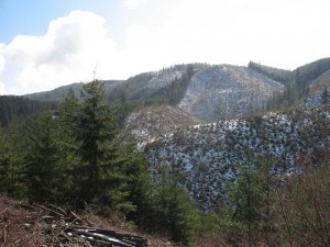 and exhaustion is as real today as ever. Even with a well maintained road this route is one of the more strenuous routes – with its many climbs and descents and the long distance covered. and exhaustion is as real today as ever. Even with a well maintained road this route is one of the more strenuous routes – with its many climbs and descents and the long distance covered.
And our route stops short of completing the trek all the way to Rocky Point Road. But if one were to contemplate a route from Forest Park to the Coast, it would be necessary to cross Raymond Creek and ascend the Vedanta Ridge to Jackson Creek and from there ascend to Rocky point Road. I have completed that bushwhack. Though it is difficult terrain crossing the boggy base of Raymond Creek and ascending the steep slopes to the north, this is the best route given the presence of the long road leading across the rest of the traverse to Otto Miller road.
Finally, it should be mentioned that there is yet one more route to consider. Should one bushwhack west from the 840 foot summit of the hillock that marks the end of the grade-line road, it is possible to connect with a track (visible from the hillock) that leads 1.5 miles all the way up the base of Dixie Mountain and emerges at the intersection of Dixie Mountain Road and Otto Miller Road at an elevation of 1400 feet. However, this road appears to be in private ownership and thus I do not recommend this route. |
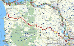 Brief summary: This walk follows a main line logging road into the remote reaches of the Gourlay Creek and Raymond Creek watersheds. This area is currently being actively logged, so pay attention to the signage that warns of logging truck traffic. But caution is advised if the gate is open and the warning signs are present. Typically, there is no logging on the weekends.



It looks to me that this website doesnt load up in a Motorola Droid. Are other people having the same issue? I like this site and dont want to have to miss it whenever Im gone from my computer.
This site was built on WordPress. I don’t know if there are tools available that I can use to make this site “roll up” on the Motorola Droid. Any suggestions. I’m willing to try to make this happen even though I’m a relative neophyte when it comes to web publishing. I try to concentrate on the content, not the web mechanics… 😉