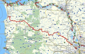
 Brief summary: This trail is mostly on rough logging road with moderate to large sized rock underfoot. The side trails that meander through the woods along the ridge top are less well paved and can be muddy in some parts – especially the the detour near the easterly portion of the trail. Beautiful views into Dutch Canyon and out into the Lower Columbia River Basin.
Distance: 4.1 miles one way; 8.2 miles round trip
Walk duration: 4 hours 30 minutes
Travel time to trail head: 55 minutes
Driving directions to the trail head: From downtown Portland drive north on US 30 to Scappoose. Turn left opposite the gas station on Bonneville Drive and then an immediate right on to Old Portland Road that parallels US 30 passing behind Scappoose. Turn left on Dutch Canyon Road, and follow it until it crosses a small creek and turns left (at the intersection with Em Watts Road). Immediately thereafter turn right on to Mountain View Rd. which will ascend the hill. Follow this road along. At 2.15 miles we pass the intersection with West Road. The road will eventually turn into “Heimuller Road” and alternatively “Holaday Road”. At 2.75 miles we pass the intersection with Smith Road and continue onwards up and to the NW. At 4.68 miles we encounter a left hand spur road, the Pisgah Home Road. We will leave the main road and turn down this westbound route. The main road continues in a northerly direction eventually turning into Sierks Road.
Passing below a farmstead the road continues until you’ve traveled 5.75 miles. At this point there is a wide intersection on the should of the ridge that marks the juncture with a spur road that serves the final house on this ridge. This is a good place to park and begin your ascent since the road gets appreciably rougher from here on out. It is possible to drive all the way though to the Vernonia – Scappoose highway, but it will take a toll on your shocks and if you’re loaded down you may end up scraping the bottom of you car going over the portions of the road paved in 4” rock. From the bottom of Mountain View Road to the recommended parking spot the elevation gain is 1284 feet, starting at 200 feet in elevation to 1484 in elevation.
Elevation change: highest elevation 2137 feet at the top of Buck Mountain; lowest 1484 feet at the beginning of the Pisgah Home Road.
Conditions: graveled logging roads, some portions with rougher grade stone, but dry and hard all the way. Walkable in all weather.
Trail directions:
Once parked, follow the road you drove in on – uphill towards Bald Mountain and beyond, to Buck Mountain. All the landmarks on this trial will be measured from the intersection and clearing where you parked. Just beyond that location the road begins to climb more steeply and the road gets noticeably rockier. On either side is low vegetation including lots of Scotch Broom.
100 feet from the start: you’ll find an informal shooting range on the left side of the road; opposite this clearing is the old road that we will be using on our return. The road is pretty obscure, but believe me it’s there hidden in the Scotch Broom.
1/2 mile from the start: you will emerge on to the south facing slope of Bald Mountain, looking down into Dutch Canyon.
3/4 mile from the start: the road curves to the right and in the elbow of the bend you should note a small trail heading off in a Northeasterly direction. This will be the route we take upon our return. But on the outbound leg of the hike continue climbing up the road and you will shortly emerge on to a wide landing carved into the shoulder of the hill (elevation about 1700 feet) and paved with large gravel.
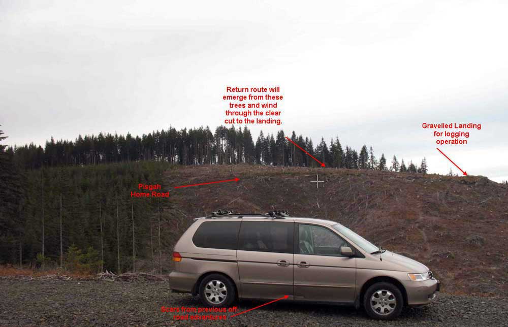
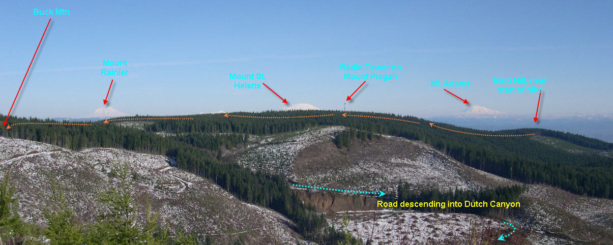
The picture below shows my car parked on a spur further down the hillside; the Pisgah Home road is visible on the hillside above the car. In the foreground you can see the elk trails coming down the slope.
 |
This is a great place to look down into Dutch Canyon, and over to the far side where Otto Miller Road ascends. In the far distance to the East you can 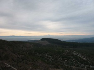 see Sauvie Island, the Columbia, and even the entrance to the Gorge. To the west you can see up to the top of Dutch canyon. Facing the top of the canyon is a nameless hill whose crown circled by the “Rim Road” (see next hike for more details). Directly to the north of that height is Buck Mountain – marking the culmination of the ridge that we are climbing. Lined up across the Eastern horizon are Mt. Hood and Mt. Adams (Mt. St. Helens and Mt. Rainier are hidden behind the ridge).
.9 miles: From this logging “platform” barely a mile into the hike, we will continue to follow the Pisgah Home Road.
What an odd name “Pisgah Home Road” is! The name refers to the Mountain from which Moses first saw the promised land. But the local story is even more interesting…
Apparently, it refers to a faith healing movement started around 1900 by Finis Yoakum at his house in Los Angeles. The home originally had room for only eight persons and was founded “to give free care to drunkards and outcasts” who wished to reform. Apparently, the effort grew into a major social initiative that inspired good Samaritans as far away as Portland, where “Mother Lawrence” took up the challenge. Hattie Lawrence was born in Wisconsin in 1859 and came to Portland at the age of 26. She seems to have copied the Pisgah Home concept when she established a Portland-based “Pisgah Home” to take care of the “down and out old men”, and it was said that the Portland police regularly brought her men that had been arrested for drunkenness. Needing a place in the country where her aged wards could do physical labor and restore their health, she acquired a piece of land above Scappoose in 1919. Apparently, she and her “down and out” men built an impressive three story shake-sided building on the logged-off land. It was surrounded by gardens and tended by old men hoeing and busying themselves with horticulture. 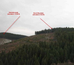 The refuge even had its own cemetery to accept the last remains of those whose relatives had forsaken them. In 1937 Mother Lawrence died as the result of a car accident. The land was subsequently acquired by local Japanese businessmen, but they were soon dispossessed by the onset of the Second World War and the land now belongs to the Longview Fibre Company.
1.2 miles: Following this road along we encounter an intersection with Rabinski Road that climbs up from a lower plateau to connect with this sylvan arterial to link with the routes to Vernonia and Bacona.
1.8 miles: the road makes another left hand curve. In the “elbow’ of the curve you can see an abandoned road (blocked by a huge mound of dirt) that leads over the crest of the ridge to connect with the northern slopes of Mount Pisgah. A segment of the Pisgah Home road links the small community of Chapman Landing (on the Vernonia to Scappoose highway) to the high meadows around the headwaters of Brush Creek. There are still some very primitive and remote homes at the top of that road, reminiscent of early settlers’ homes. But for now, our route takes us past this juncture with the north slope of Mount Pisgah Mountain, as we continue to climb the long ridge towards Buck Mountain.
2.2 miles: You’ve just climbed over the 2,000 ft level and as the road flattens outs you will pass a spur road on your right that leads to a radio tower. On our return we will visit this tower.
2.3 miles: you will arrive at an intersection with a spur road that leads off to the left, and another that leads uphill into the forest to your right. On our return trip we’ll be venturing up this upper spur road that runs along the very top of the ridge. The other spur road on the left follows a series of narrow clearings until it narrows into a rudimentary track that penetrates about a half mile and ends at the edge of the tall timber overlooking a clear cut at the top of McLafferty Creek. We will ignore this option and instead follow the main route over the top of the ridge and proceed northwards.
2.5 miles: As you emerge from the taller timber you will be crossing the top of the ridge at 2091 ft. From there the roads bends westwards and soon thereafter it connects with the main road coming in from the Scappoose – Vernonia highway.
3.25 miles: Now we’ve reached the intersection with the main north-south route – also called the Pisgah Home Road. It seems as if every road in this area is called the Pisgah Home Road. But more logically it simply reflects that the Pisgah Home Road that we have been traversing now heads right (north) until it connects with the Scappoose to Vernonia Highway. To the left this north -south arterial continues down the slope into Dutch Canyon.
Originally this was only a jeep trail, but now it is a reasonably well maintained gravel road – despite the fact that it no longer has a name. Eventually this road circles a quarry, crosses the South Scappoose creek and skirts a lovely little pond before heading up the western flank of Dutch Canyon. At the top of the Tualatin Range it connects with Tupper Road and debauches into the Wilderness Road that leads to the Smoke Ranch on the western slope of this range.
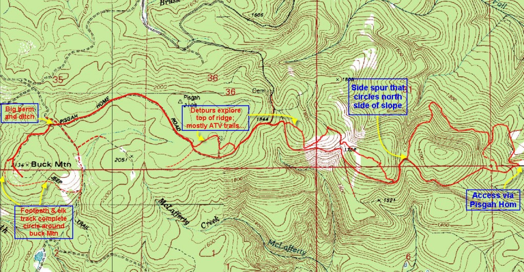
3.25 miles: We will cross this arterial and take a primitive track westward from this 4 way intersection. This route is blocked by a big mound of dirt and a deep gully to prevent ATV from accessing it too easily. However, it is clear from the alternative tracks that this obstruction was temporary – at best. This rough track leads around the northern face of Buck Mountain.
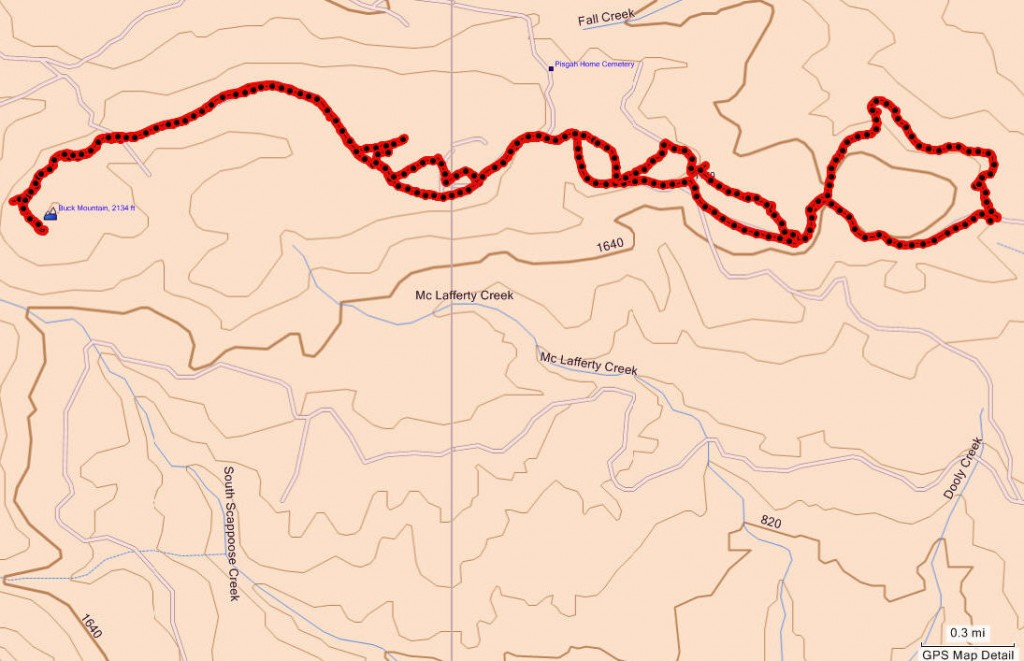
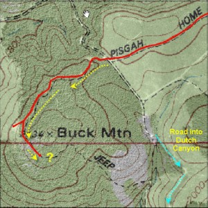 3.67 miles: On the western face the trail breaks out of the timber to afford a long view into the Coast range. From here it is possible to see the top of Saddle Mountain – a peak that overlooks the Pacific ocean! Venturing further along we eventually reach the southern exposure of Buck Mountain. From the most westerly point (short red prong on map) one can traverse the western slope heading south via an ATV track, and then as the ATV trail heads downhill turn left on an elk trail that traverses the slope to the small stand of tall trees. Just past those isolated trees you’ll arrive at the access road coming up the hill from the southern slope.
3.83 miles: But from the brow of the hill at the edge of the timber (elevation 2096 feet) you can look out into the Columbia basin and all the way up into the Columbia Gorge.
As an unimpressive as the end of this trail may seem, it hides a significance that is much larger, much older and much subtler than most will realize. To understand the magic of this place, let’s consider some of the quieter attributes of this place.
As we paused earlier to peer westward, we might  have noticed that a small valley separates Buck Mountain from its nameless twin to the west. In that fold, the first dribbles of moisture flow together and coalesce into the headwaters of South Scappoose Creek draining around the southern face and dropping down into Dutch Canyon and eventually flowing into the Columbia River. But looking a bit further , we would have seen that another stream drawing sustenance from the north slope of Buck Mountain fed a marshy pond that emptied into Panther Creek, the highest tributaries of Dairy Creek. Dairy Creek eventually flows down into the Tualatin valley near North Plains and from there flows past Wapato Lake, where only a century ago the Atfalati Indians congregated. Looking North a low ridge spans the foreground. This height of land holds a series of small misty ponds (Gunners lakes) that catch the seepage from these perennially damp forests.
  Small streams escape from these shallow pools and cascade in miniature rivulets over beaver dams and through boggy glens to reach the Nehalem River which flows into the Pacific ocean just north of Tillamook. Turning to look northeastwards along the way we entered this hillside vantage point we might spot a forested hilltop directly to the north. Tater Hill marks the ridge line that separates the rivers flowing south into the Willamette, and those flowing west into the Pacific ocean, from those that flow eastwards into the Columbia River.
Unobtrusive as this forest clogged hilltop seems, it marks a major intersection of watersheds that delineate the western edge of the Columbia River basin, the northernmost reach of the Tualatin basin, and the easternmost reach of the Pacific coast watershed!
Had we come here two centuries ago, we would have reached the northern limits of the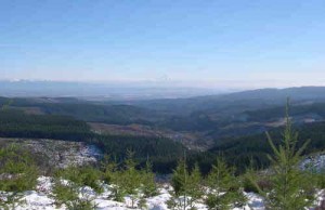 Atfalati’s hunting grounds. To the east the Chinookan tribe of Kiersinno Indians held sway. And to the north the Athabascan villages of the Klatskanie Indians hunted the mountains and taxed the river traffic along the Columbia river. This was as finite a border as we can imagine with trading patterns, hunting rights and transportation tolls firmly established. The Atfalatis in this region were granted the right to hunt seals in the Columbia River, in exchange for which the Klickitats, who lived on the north side of the Columbia, were allowed to hunt the game-filled forests above Washington County. Unlike the coastal and River Indians, the northern Atfalati from the Forest Grove area were known to be active hunters, since their access to fishing was seasonally limited to when high water levels introduced more fish into their interior streams. The Atfalati traded with the Tillamooks and the North Coast Salish Indians for fish, whale meat and abalone shells. And they traded berries and game with the more affluent Chinook Indians along the Lower Columbia. But fishing in the Columbia remained exclusively the right of the Chinook River Indians that lived along the banks of the “Wimahl” (big river). Throughout this area trails crossed the Tualatin Range to connect the valley dwellers with the river -side denizens. The best-know of these trails was the Logie Trail to crossed from Washington County down to the Multnomah channel alongside Sauvie Island.
 From this spot on Buck Mountain it is possible to peer West into the multiple green folds of the Coast range and spot the telltale shape of Saddle Mountain marking the boundary of the coastal strip. To the east one can just discern Multnomah Falls and the beginning
  of the Gorge that marks the transition to the plains of the interior Indians – derisively referred to as the “shoshones” by the Willamette Valley Indians. This was a “world-spanning view” that allowed natives to glimpse across the entire breadth of their world, and even to peer north into the lands across the the big river. Even today this remote divide of waters, peoples and cultures conjures up deep forces of spatial power. Had druids lived in these parts, they would have anointed this hill with a crown of stones. Though uncrowned and unrecognized, this remote hillock still exudes a sense of place that helps to ground me every time I peer out from its tree-lined brow. Tarry a while and let it soothe your soul…
The return trip:
Much of the return will entail backtracking along the route we walked in on, but at various points I have provided nice detours that skirt the top of the ridge and explore the more primitive side routes along the top of this long descending ridge.
Tarrying at the crest of Buck Mountain, we let our minds drift to distant days when the span of man’s life might not stretch much beyond the horizon, but the depth of their experience encompassed a wealth of natural detail long since lost to the facile grasp of modern man. But hey, we’re contemporary specimens so we haven’t much time to waste and we’ve got to retrace the 3.83 miles we covered to get to this special spot – before we turn into pumpkins!
4.3 miles: It’s less than a half mile back to the main north-south artery that marks the beginning of the track around Buck Mountain. At this point the Pisgah Home road comes in from the north and turns east at this intersection to straggle down the Pisgah Home ridge towards Scappoose. That’s the route  we came in on. And it’s the way we’re going back, with a couple of side detours – just for kicks!
5.25 miles: Following the road we used on the outbound leg we climb the ridge line above an old clearcut. Off to our left and about 20 feet above the level of the road is a high point hidden in the trees that marks the 2108 foot summit of Pisgah Mountain. Shortly thereafter we enter the taller trees and arrive at the forested intersection that we passed (Mile 2.3) earlier. This time we will leave the main trail/road and ascend the track that branches off to our left and climbs up the forested slope towards the high point of the ridge line we’re following.
 5.4 miles: Just a short distance onwards will bring us to the radio tower that crowns this hill. As we take the road downwards to our right and descend toward the main road, we’ll see a series of ATV tracks that head off eastwards through the trees. Let’s follow these through the open the forest and eventually they will emerge at a depression where the ATV barbarians with their excess of testosterone, steel and fossil fuels have converted a forest dell into a slough of despondent mud. Thankfully it’s just a short path back to the main road from this desecration.
5.55 miles: We continue down the main road retracing our inbound steps, skirting below a picturesque clearing bounded by tall timbers on our left.
5:85 miles: As we enter a shallow leftward protruding “elbow” in the road, we will see a spur road leading northwards behind a high dirt barrier or “berm” to prevent vehicular access. This route leads down into the northern slopes and the upland pastures at the top of that portion of Pisgah Home road that can be accessed from Chapman Landing on the Scappoose-Vernonia Highway. But we will bypass this spur road in favor of …
5:95 miles: …a smaller spur road that climbs directly uphill in the very next bend heading upwards towards the high point of the ridge on our left. This road climbs the 36 feet to the top of the ridge (6.03 miles) and then slips down the slope as it traverses eastwards.
6:15 miles: Eventually it approaches the main road again, but just before it joins with the main road it turns and parallels the main road traversing the forested hillside – running roughly parallel to the main road (down the slope to your right). This track heads gently uphill into the forested ridge line. On the far side of the ridge line it begins to descend gently northwards. Here the path narrows amongst thickening vegetation. Don’t worry that you’ve gone astray, because presently this wandering trail drops down to connect with the end of another primitive road.  Follow this road back almost towards the main road.
6.5 miles: But just 50 feet it debauches on to the Pisgah Home road, we will chose to ascend another graveled road that leads off to your left and climbs eastward up the next rise along the ridge. Let’s follow this well maintained road through a thinned forest of taller timber crowning the ridge line. This road follow the promontory before turning gently to the left and descending northwards.
6.7 miles: This is a bit of a tricky point! At the point where  the road begins to turn leftwards at the end of the high point of the ridge, stop to look around you and survey the right hand side of the road. Just before the road turns northward away from the edge of the forest, you should spot a footpath wending its way from the road toward the edge of the trees to your right. You can always bushwhack to the edge of the clearcut, but there is a clearly visible path to follow it you look at that point of the road that is closest to the edge of the clear-cut.
6.78 miles: This short path will lead you to the edge of the clear-cut over looking Dutch Canyon. From here it’s simple to pick your way through the open clearcut down to the promontory below you and slightly eastwards of your current position at the forest’s edge.
6.90 miles: at the base of the bushwhack we arrive at the promontory that has been widened to accommodate the heavy logging equipment used to haul the logs both up and down this slope. Both the exit point from the forest and the logging platform are marked on the previously appended photo showing my car parked lower down this slope. From this promontory we continue to retrace our steps back down Pisgah Home road.
7.08 miles: As we come into the next elbow in the road, we should observe a small footpath leading out of the curve to the northeast. This is a small path, but clearly much used as it is clearly visible. Apparently this is a favorite hunting ground for mushroom harvesters since I once found a whole cupboard drawer filled with wilting chanterelles at this spot. If you look into the bushes at the start of this path you can probably still spot this decaying chest of drawers lying in the undergrowth. This narrow footpath will now take you down the north face of the ridge. Don’t despair that you’re now heading in the wrong direction, because eventually the path will swing back around again and head in a southeasterly direction returning you to the Pisgah Home Road. Eventually the road/path will lead down the northern face of this hill and will drop from 1641 feet in elevation at the start of this side trail to 1421 feet.
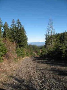 7.5 miles: At this point the road, descending in an easterly direction, will abruptly turn to make a U turn and resume its descent heading in northwesterly direction. Also joining this intersection from your right will be a less traveled road coming down from the Southeast. This right hand side-spur looks tempting – as if it heads back to the ridge and Pisgah Home road. In fact it does, and I originally used this route, but it’s terribly overgrown and is tough to bushwhack through.
8.06 miles: Instead follow the main road down a bit further. It soon intersects with a decent road coming in from the right. This is the road that will lead you back to Pisgah Home Road without having to wrestle the vinemaple for access.

I was curious if on your hike you came across the cemetery? A group of us have made multiple attempts to locate the cemetery without success. We would like to find it to be able to record and photograph the markers.
No, I never have found it or even tried. Frankly it never occurred to me. I would begin by asking the folks who live on the farm whee the dirt road commences. It’s likely to be further down the shoulder of the hill than we think. Also from what I recall from the description there weren’t that many folks actually interred at the “Pisgah Home” – only those who’s family didn’t claim their remains. If you’re going to find it start by asking the resident; it’s amazing what kids can find. Let me know if you “unearth” this mystery. Jim
I rode my motorcycle up Rabinsky Road this morning with the hope of finding a route to Vernonia. I ran into some private property signs on the Pisgah Home Road. when I was making my way to the Bacona CCC Road. There was no gate, but I turned around. Do you know anything about public right-of-way for the Pisgah Home Road?
We have been interested in finding the Cemetery also, so far we have found 4 locations based off topo maps. We have a friend who told us that he came across it about 50 years ago. As he recalls most of the grave markers where wood. Most had rotted and fallen down. At the time there was still wrought iron fences or gates on some parts. I’m not holding out much hope finding it.
My brother suggested I may like this blog. He used to be totally right. This publish actually made my day. You can not consider just how much time I had spent for this info! Thanks!