
Elk Mountain and King’s Mountain loop
General description: Steep climb up Elk mountain followed by rugged ridgeline traverse to King’s Mountain, culminating in a steep descent. The last 3.5 miles is a roughly level trail paralleling the Wilson River and nearby highway.
- 10 miles; duration roughly about 6-8 hours. The terrain is rugged forcing a slower pace than the normal 3-mile per hour gait. The ascent can be as slow as .7 miles/hr.
- “Strenuous”: better suited to the hiker in good condition. A good pair of boots is recommended for traction and ankle stability. This loop is one of the more challenging hiking routes included in this guide.
- Elevation gain: 4.32 miles uphill distance; average uphill grade is 22.4 %
- Elevation loss: 4.11 miles downhill distance; average downhill grade is 24%
- Trail conditions: Trail was well groomed and is not particularly dangerous from the perspective of traversing open faces, or being exposed to sheer drops. King’s Mountain descent lacking adequate switch-backs which might make the climb more difficult in wet muddy conditions.
- Special attributes: Dramatically steep rock formations and views over the crest of the Coast Range of Mt. Hood, Mt. Jefferson, and Mt. Adams. Saddle Mountain visible to the west.
- Trailhead at Elk Creek Campground, or at the gate leading into the campground. Equestrian use forbidden, bikes only allowed on the Elk Creek Trail.
Trail Log:
Starting at the Elk Creek Campground, follow the Wilson River trail in a westerly direction. Don’t go up the creek that’s the Elk Creek Trail – a scenic but much longer route. A quarter of a mile up the Wilson River Trail one encounters the junction where the Elk Mountain Trail bends upwards through the red alders and begins its serious ascent up the face of Elk Mountain. This climb is interspersed with open places offering fabulous views of the river and the forested slopes of the coast range. Given the steepness of the climb, you will not only enjoy the views, but also quietly give thanks for the excuse to pause during the grueling ascent. The Tillamook Burn devastated much of this area, and the tall snags that adorn these precipitous slopes are a lasting testament to the vast destruction that occurred during those fires.
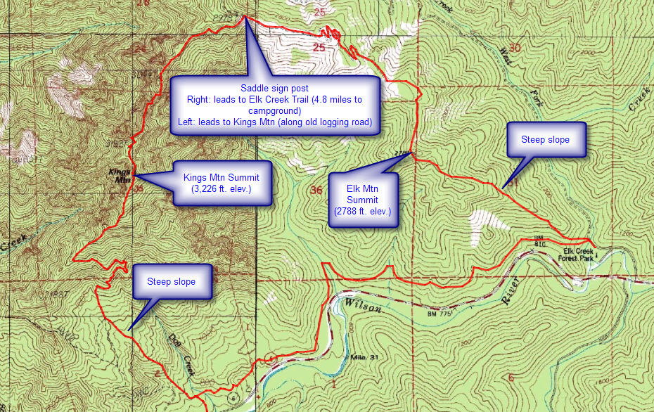
The trail skirts the northern slope of Elk Mountain and ascends the ridgeline. A false summit about 1.5 miles up the trial affords fabulous views, but the main trail circles the base of this promontory and continues on to the real summit (elevation 2,788 ft.) a half-mile further. From this vantage point it becomes clear how precipitous the coastal mountains can be underneath their usual camouflage of greenery, and how dangerous it can be to attempt unmarked descents in these areas. Summiting Elk Mountain is the hard part, but the trail continues to twist along the narrow ridge top for another 2 miles. There we emerge at a saddle that marks the top of the Elk Creek Trail (4.8 miles back to the bottom), and also the beginning of the Kings Mountain connector trail – heading off to the left
Follow the King’s Mountain trail to the left, as indicated on the signpost. It will guide you over to the next promontory. There a narrow ridgeline path leads you out to a high point at 3227 ft., known as King’s Mountain. The views across the Coast Range are spectacular, with Saddle Mountain off to the Northwest. In that same direction you can spot the Standard Grade that traverses the entire backbone of the mountain system from Buck Mountain over Roger’s Peak, past Larch Mountain to Round Top overlooking Cochran Pond.
Directly below King’s Mountain is Lee’s Camp, a popular spot for ATV enthusiasts. Unfortunately, it can sound like a hornets’ nest on some busy weekend days, as the ATV’ers snarl their way along the valley floors. But it’s a distance annoyance, if you allow the myriad of peaks around you set the tone and impress you with the enormity of their expanse. Tarry a while on the bare slope near the Mazama summit box; it’s all downhill from here.
But it would be disingenuous of me to suggest the rest is easy. The descent is indeed a challenge; the first time I did it my thigh muscles screamed in agony. So take it easy, and take frequent rest stops to allow your leg muscles to recover. About 2 miles from the summit, or a half-mile from the highway, the descent crosses the Wilson River trail. Turn left and follow the signs for the Elk Creek Campground, another 3.5 miles to the east. This trail is relatively flat, the level path will appeal to most.
A half-mile from the Elk Creek campsite you’ll pass the Elk Mountain trail where you began this “walk in the woods” nearly 10 miles earlier. Continue on a half-mile to the camp. If the gate is closed you’ll have to walk another half-mile to the roadside parking. Collapsing into your car will feel glorious at this point, but be careful driving home on the Wilson River highway; it’s a windy journey as well!


4/28/17. No mention of the rope you have to use going from King Mtn to Elk Mtn!!
You’re right I should have noted that, and few other places where ropes are present – and necessary.
Jim
“Trail was well groomed and is not particularly dangerous from the perspective of traversing open faces, or being exposed to sheer drops.”
This isn’t just wrong, it’s dangerously wrong. Elk Mountain “Trail” is NOHING BUT SHEER DROPS ALONG THE ENTIRE ROUTE.
What could motivate you to have written what you did?
I guess it’s all relative. This is one of the more vertically challenged trails, but it continues to be a very popular route. On any sunny week-end you’re likely to find dozens of groups climbing Elk Mountain. If you want a gentle ascent use the Elk Mtn. Creek trail. It’s longer but the ascent is not so vertical. I grew up climbing steep slopes, but I never carried or used ropes. This ascent while tiring isn’t restricted to rock climbers, nor does it require a rope. For another gentler ascent try going up King’s Mtn and them descending along the Elk Creek Trail. Basically reverse the direction of the hike.
Sorry, if this ascent was too exposed for your comfort. It is the toughest climb in the book.
Jim Thayer
You literally said in a reply to the other commenter that rope is required yet you said in response to me that rope isn’t required.
Figure out how you feel about this climb then write a proper review about it.
Heading up or down Elk Mountain is dangerous as hell.
You can say experience blah blah blah… but I’ve got experience and that “trail” is dangerous as hell.
The fact that many people do it doesn’t make it less dangerous.
Many people also drive on the highway and that’s not safe either.
For anyone reading these reviews, take note: this pseudo-trail is dangerous and only for extremely skilled hikers.
What Nathan Strong said!
I don’t care how you try to slice it, this hike is dangerous. Period. Is it worth doing for an experienced hiker who is confident when scrambling up/down a narrow, mossy, very slippery when wet (which it often is), extremely steep, switchbacky excuse for a trail, sure.
But keep in mind that there’s a good reason that you pass a helicopter pad near the top, half the trail is such that if you fall, you WILL be very seriously injured or quite possibly die. I don’t want to discourage anyone, but respect the Kings mountain/Elk mountain loop. It’s no joke.