The Tualatin Hills are not just “a walk in the woods”!

During the 1830’s the famed Methodist circuit rider, Jason Lee, is said to have established a road across the Tualatin Hills that connected Scappoose and St. Helens with the communities in northern Washington County. It is very possible that today’s gradeline road that twists across this hillside may once have been the route that carried this fiery circuit rider down into the Lower Columbia River. But even today the hike from Dutch Canyon to Rocky Point Road is not for the faint-of-heart.

But a more tragic story is told of Albert Lange who walked this same route in the early years of the twentieth century, but like so many others that under estimate the dangers of hypothermia, he did not live to tell his tale…

Hunting with his two dogs he had traversed this mountainous terrain encountering snow, thick vegetation, ridges and canyons, thickets and fallen trees. Most likely he would have passed close to Raymond Creek and may have ascended into the property that is now owned by the Vedanta Society. Near the end of the day he emerged from this trek on to Rocky Point Road, where he met Abe Cornelius, another of the original settlers on Dixie Mountain. Abe recommended that Albert take nourishment at his home before trying to return to Dutch Canyon, but Albert demurred. It appears that his dogs now treed a coon, which Albert shot and skinned. Later he was also able to kill a deer and dress it near the Mozee homestead before starting for home. The search party was later able to piece together his movements, which now clearly showed signs of fatigue and possibly hypothermia. Falling off a log he rolled down the hill in the snow, but he continued down the ridge. Eventually he fell in the snow and failed to rise. It is reported that when the search party finally located him a couple of days later the dogs were found with their noses in his arm pits as if trying to raise him out of the snow. Their loyalty in protecting their master complicated matters for the rescuers, but eventually they were able to separate the dogs from their dead master.

Though there are few among us that would be able to traverse such a wilderness for 6-7 miles, the lessons of exercising prudence in the face of the elements and exhaustion is as real today as ever. Even with a well maintained road this route is one of the more strenuous routes – with its many climbs and descents and the long distance covered.

Posted in Lower Columbia Trails, Misc Trails & Trips, Pioneer Lore | 3 Comments

Pisgah Home Road – what’s behind this curious name?

What an odd name “Pisgah Home Road” is! The name refers to the Mountain from which Moses first saw the promised land. But the local story about this mountain road above Scappoose is even more interesting…

Apparently, it refers to a faith healing movement started around 1900 by Finis Yoakum at his house in Los Angeles. The home originally had room for only eight persons and was founded “to give free care to drunkards and outcasts” who wished to reform. Apparently, the effort grew into a major social initiative that inspired good Samaritans as far away as Portland, where “Mother Lawrence” took up the challenge. Hattie Lawrence was born in Wisconsin in 1859 and came to Portland at the age of 26. She seems to have copied the Pisgah Home concept when she established a Portland-based “Pisgah Home” to take care of the “down and out old men”, and it was said that the Portland police regularly brought her men that had been arrested for drunkenness. Needing a place in the country where her aged wards could do physical labor and restore their health, she acquired a piece of land above Scappoose in 1919. Apparently, she and her “down and out” men built an impressive three story shake-sided building on the logged-off land. It was surrounded by gardens and tended by old men hoeing and busying themselves with horticulture. The refuge even had its own cemetery to accept the last remains of those whose relatives had forsaken them. In 1937 Mother Lawrence died as the result of a car accident. The land was subsequently acquired by local Japanese businessmen, but they were soon dispossessed by the onset of the Second World War and the land now belongs to the Longview Fibre Company.

Posted in Uncategorized | 24 Comments

Portland landscape 200 years ago.

When I’m climbing in the hills above the Columbia River I often stop to gaze down into the valley and try to imagine what it looked like before contact with the European cultures. Most people’s preconception of what the lower Columbia river basin looked like when the first people ruled the roost is of a vast forested area dotted here and there with small bands of Indians that wandered about sporadically in pursuit of game, salmon, wild onions punctuated with an occasional raid on their neighbors.

But in fact, had we looked down upon the confluence of the Willamette and Columbia River 200 years ago we would have seen a landscape very different from today’s crisply maintained waterways.

Imagine it’s 1750 and we’re that we’re standing atop the Tualatin Ridge gazing northwards just as the sun crests the cascades mountain to the East.  With  light flooding across the Willamette Valley, we would have had to shield our eyes to peer down to see Sauvie Island and the confluence of the Columbia River with Willamette River. In this early light the Columbia River would have appeared like so many pewter ribbons threading their way through a maze of sandbars, side channels and islands, splitting and regrouping as it surged northward.  And along the river’s swampy boundaries, we would have spotted twisting columns of smoke ascending lazily from scores of plank houses clustered densely on the banks of the big muddy river. Upon closer count, no less than 16 Multnomah and Clackamas Indian villages would have been visible immediately below our lofty observer.

To the modern observer the lack of a clear and continuous shorelines would have been immediately apparent. Instead of a clearly defined river, the many channels and tributaries extended well beyond the main channel and formed a vast bayou of intertwined islands,  innumerable streams, stagnant inlets,  land-locked ponds,  tidal lakes, marshes and flooded woodlands. During the spring floods much of the area would be submerged and the main stem of the muddy river would be clogged with huge debris piles, floating logs and rafts of jumbled flotsam.

Visually the most arresting feature would have been the ubiquitous stands of timber that bordered every waterway. All along the major channels the shores would have been crowded with thick riparian belts of ash, black cottonwood, willows, big leaf maples, Douglas Fir and Western Red Cedar that grew in rich profusion. Only in the vicinity of the villages, where the Indians had harvested wood for firewood did the trees recede. Occasionally the careful observer might also spot portions of the shoreline that had been intentionally burned but had since regrown with willows. This selective clearing and subsequent targeted propagation was intentional to ensure a handy supply of willow wood with which to make  infant cradles, headgear and household utensils.

Indeed, the entire landscape would have been profoundly affected by the Indians practice of burning the forests and fields throughout the region. Here our observation would have to rely less on our visual acuity, but more upon our understanding of the natural and human processes at work in the landscape. So a knowledgeable Indian standing beside us might have explained that the sharp transition from tall stands of timber alongside the waterways to the grassy clearings interspersed with islands of white oak was no natural accident, but was instead the direct result of the Indians’ fire induced land management.

In the late fall after the annual burning, these cleared areas would have clearly shown the effects of the fire induced thinning. Shielded by their thick bark, the oaks withstood the seasonal scorching and rewarded both humans and deer with their bounty of acorns. In between the copses of oaks the charred clearings soon regenerated into a lush crop of native grasses, including Blue Ryegrass, Idaho bent grass, California Oatgrass, Needlegrass and Tarweed. To the unfamiliar eye, this diverse ground cover held no significance, but to our native observer these grasses would have represented yet another important source of food. Tarweed, for example, is a sunflower-like plant that grew throughout the region. The fire would scorch this tall plant removing the sticky tar substance and leaving the husk full of seeds ready to be harvested. Burning away the ground cover, would also have facilitated the harvesting of the grass seeds, as well as exposing a delicious bounty of roasted crickets!

Beyond this transitional growth the landscape opened up into wide savannahs and luxuriant grasslands that stretched south all the way to the end of the Willamette Valley and up into the forested foothills on the valley’s eastern and western flanks. Only where the valleys rose up the flanks of the foothills did the Douglas Fir, Ponderosa Pine,  Hemlocks and Big Leaf Maples reasserted their arboreal dominance. And even there the Indians were fond of burning swathes of cleared land on the western facing slopes to help the propagation of huckleberry patches. Near the summits, hunter were wont to fire the ridge lines to provide corridors that would attract the deer and elk to the new growth, and make hunting easier.

Most of the human habitation was concentrated along the lower Columbia extending from the Sandy River down to the Cowlitz river, a region sometimes referred to as the “Wapato Valley”. This basically encompasses what is now the Portland/Vancouver metropolitan areas, on down to Kelso, WA. It is estimated that this region was home to more than 14,000 people, and that prior to the first huge epidemics in the 1700’s, the population may have been as high as 30,000 to 40,000 people. These population densities in the early 1800’s equate to more than 1 person per square mile.

But before the devastating epidemics of the 1700, the population density rises to an astounding 3.1 people per square mile – a remarkable population concentration give the fact that most of the habitation was located along the banks of the river and that this was a hunter-gather society that did not cultivate plants in any organized fashion. How was it possible to sustain that many people without an significant agricultural efforts. The answer lies in the remarkable fecundity of the Columbia River basin. It was home to elk, bear, dear, beaver, ducks, geese, sturgeon, salmon, smelt, wapato bulbs, camas bulbs, a profusion of berries including salal and huckleberries. Historians think that the Columbia River may have been the richest river in the world disgorging between 11 and 16 million salmon per year. And the Indians are estimated to have caught more than one fish in three! This early map below shows the absolute profusion of fish weirs, and fish traps on the lower Columbia River.

Returning to our vantage point looking down towards the lower reaches of the Willamette River, we can easily see wood smoke rising from numerous plank houses clustered along the river that comprise several villages of the Multnomah Indians. Dogs wander in and out of the lodges, unheedful that their final destination will be in the Indian stew pot. As it lightens there’s activity stirring around the villages with women emerging from the small entrance at the front of the plank house. They’re probably going out to check the overnight catches in the many fish weirs constructed all along the river’s shallows. But mainly everyone seems to be getting ready for the spring runs of salmon. Back from the river shore, we can spot a group of women carefully gathering plants growing on the sandy soil. Judging from the delicacy of how they handle the plants we can surmise that they must be standing in the middle of a nettle patch! Despite its unpleasant reputation the Indians considered this the best plant from which to make strong and silky lines which were ideal for fishing – and were thus in high demand as the seine nets were being repaired for the spring salmon run.

On the north shore we spot another group of women walking into the interior of Sauvie Island. They’re shouldering a small canoe on their shoulders as they thread their way through the vine maple thickets that surround the waters of Sturgeon lake. From our lofty vantage point we can just barely see them wading out into the water until they’re nearly waist deep in the muddy lake. The women pause, and pensively shuffle around in the waist deep water feeling the bottom of the pond with their toes. Presently one of the women slips her toes around a wapato root and with a slight pull dislodges it from the bottom of the pond. It quickly pops up to the surface whereupon she tosses the bulbous root into the little canoe that is floating alongside her. Clustered around her the other women are also retrieving the dislodged roots and depositing them in their floating wheelbarrows.

Later in the year, we might have seen the Indian women wearing long conical baskets fanning out into the grasslands to fire the grasses. Systematically the Indians would fire all the grasslands that extended down from the forested hillsides – all the way to the riparian strips that clustered along the waters edge. It was hot and smoky work and it  reduced visibility to just a few yards. Later the women would return to harvest the newly exposed seeds into their gathering baskets. At times the men would organize the burning strategies  to drive the game into the reach of the waiting hunters.

Back at the village, the men are now emerging from the plank houses. Several of them are leaning on their typical chinookan paddles so recognizable because of the triangular scoop and the straight-edged end. Others are collecting their bows and arrows and stringing new bow strings. Aside from this gear most of them are entirely naked – as was the custom for men through most of the warmer months in the year. Apparently, they are planning to hunt the huge Roosevelt Ek that frequented the wooded slopes – probably to smoke and then sell at the annual “rendezvous” above the Cellilo falls.

Eventually, they drag one of the canoes down to the water and after a boisterous send-off we observe them paddling down a small channel that separates the island from the western shore. About a mile down what we now call the “Multnomah Channel” they disembark on the western shore. The hunters are barely visible as they wade through fields of luxuriant grasses. Dotted throughout the landscape White oaks provide shade and cover. Eventually the forest begins to take shape around them as they ascend into the foothills of the Tualatin Range.

Had we the eagle eyes to recognize the trees into which the hunters were climbing, we would see that it too differed markedly from today’s forests. Of course, the slopes were covered in majestic old growth Douglas Fir trees, mixed with stands of Grand Fir and Ponderosa Pines. And the ground was uniformly covered in the Oregon grape and salal that is still ubiquitous today. But there the similarity would end, because the Western Hemlock that grows on these slopes today would have been largely absent. Even the western cedar trees would mainly be found congregating further up the Willamette, near present-day Portland.

But where are these hunters going? Though we cannot see from our lofty vantage point they are traveling one of the oldest routes in the region. This trail had for years been the main route for crossing the hills and from there gaining access to the savannahs that provide a clear passage all the way south through the lands of the Calapooyans to the foothills of the Siskyou mountains.

Even the shoreline was unrecognizable to modern eyes. Gone were the well defined river banks and instead we see endless streams and inlets piercing the river banks and shallow bayou’s along the river’s edge where fish swam into the myriad inlets, streams and shallow ponds. And there we would see a the handiwork of the Indian fish trappers with their wooden weirs, basket traps and wooden fishing platforms. The eastern shore of Sauvie Island had the recognizable beaches, but all along the length of the island small streams breached the shoreline feeding shallow channels that penetrated deep into the interior feeding into Sturgeon lake.

And everywhere, we can see the smoke rising from the hundreds of plank houses scattered across the landscape, and from these villages we can spot footpaths leading up into the berry gathering grounds on the western facing slopes that caught the warm afternoon sun. Trails also ascended both the Tualatin Hills and the foothills of the Cascades on the eastern shore of the river. These trails climbed to the crests, where hunters torched the enormous stands of virgin timber to create artificial clearings. It was in these riparian areas that elk and the deer would emerge from the gloom of the forest to enjoy the young vegetation that grew there. And it was there the hunters would return to hunt.

But in the meantime, the hills burned and smoke filled the sky. Along the entire inland valley that stretched from the headwaters of the Willamette River to the Puget Sound a pall of smoke would hang heavy from July into late September. It was so thick that Indians didn’t dare navigate beyond the immediate shoreline in the Puget Sound, lest they be lost interminably in the thick smoke that hung over the region.

So far our observers have been looking northwards towards the confluence of the Willamette and the Columbia – an area now dominated by shipping facilities in the industrial Rivergate area and farming on Sauvie Island southern edge.

The area of downtown Portland, teeming with human activity today, was virtually deserted in those distant days. The difference lay in the way the Indians used the land. For them prime real estate was was defined by the proximity of migrating salmon or immediate and visual access to transiting canoe traffic on the main stem of the Columbia river. SW Portland had none of these qualities, and shaded from the warm afternoon sun by the hills it lacked even decent huckleberry patches. The area was dominated by a large pasture that occasionally hosted temporary Indian gatherings, but it was not a well frequented area. The streams that descended from the steep slopes hosted native populations of trout, but in the native food chain trout were a trivial resource  that could not sustain any village for very long. It was across the river at the mouth of the Clackamas that the Indian congregated to collect their harvest of salmon. Further up the river  the falls did provide good reason for the Indians to congregate. It was there that the Indians would gather in early summer to wade waist deep into the vast pools of eels gathering at the base of Willamette Falls. Reaching into the water they would grasp armfuls of the writhing eels and toss them onto the shore where children competed to gather up as many as they could  before the eagles, ospreys and giant Columbia River condors snatched the wriggling fish  from the rocks.

The landscape of pre-contact was no more “natural” than it is today, but the patterns differed markedly. All activity radiated from the river’s edge which was both the major transportation arterial as well as the greatest source of food and commerce. The early settlers with their land-based paradigm of wagons and cattle were blind to the “organization” of the natural resources that their predecessors ahd bequeathed them.

We leave our observers now, as the warming day floods light over this riverine landscape. With the help of our native host, we marvel at the industriousness of the Indian fishermen whose ubiquituous weirs, fish wheels and seining pervaded the myriad channels and bayous of the river. Everywhere canoes were plying the great watery highway fishing and trading as part of the complex system that enabled the survival of such an intense concentration of people in such a small area.

Just visible under the clouds our erstwhile observer would have been able to spot the snow-dusted hills that mark the lower slopes of Cascade Mountains. No doubt our long-ago observer would have taken comfort from the presence of the great  “sentinel” mountains hidden in the clouds. Like great soldiers, the majestic peaks of Tahoma (Mt. Rainier), Loo-Wit (St. Helens), Klickitat (Mt. Adams), and Wy East (Mt. Hood), had stood guard over this richly endowed region since the Indians’ arrival nearly 10 thousand years ago. Unfortunately, the next two centuries would prove the demise of their heretofore sustainable lifestyle. Will our approach prove more or less sustainable – it remains to be seen by the next observer.

Without a doubt the overwhelming fecundity of the region and the strategic importance of the Columbia River influenced both native and subsequent immigrant economies. The Chinook were prodigious traders swapping goods from Alaska to California and from the mouth of the Columbia to the western plains of Wyoming and Nebraska. The Hudson Bay quickly learned this same lesson when they quickly turned to exporting fish and timber within 5 years of establishing the fort in Vancouver. It wasn’t until the first wave of “overlanders” arrived in 1843 that the river-based paradigm was overturned by an army of cows and wagons and the subsequent agricultural development that ensued.  And from that point onwards the land began to change in ways that would erase the prior organization of nature that had served the Indians for over 10,000 years. In response to an international market system, the civilization of Oregon would obliterate the legendary fecundity of the Columbia River Valley – reversing ten millennia of communal stewardship in less than 150 years of private exploitation.

Posted in Indian lore, Lower Columbia Trails, Misc Trails & Trips, Plant lore, Uncategorized | 3 Comments

“Sauvie” Island? Why not “Logie’s Island” or even “Wapato Island”?

Nowadays the island at the confluence of the Willamette and Columbia Rivers, is referred to as “Sauvie Island”, or sometimes “Sauvie’s Island” by the older residents. It’s a favorite spot for Portlanders to cycle, to hunt water fowl, or even to go skinny dipping in the summer months. But historically, this low-lying island  within the tidal pull of the ocean has been associated with several other important local entities, which far exceeded the humble contributions of the cow-herding Laurent Sauvé.

Wapato Island:

Although this island serves only as a recreational footnote to the region today, it was the absolute epicenter of human habitation for thousands of years in the past. In what is now known as Sturgeon Lake and in all the bayou-esque waterways that serve as the intestinal tract of Sauvie island’s aquatic landscape, there resides an aquatic plant that sports a large bulbous head to anchor it to the muddy lake bed. Known to the Indians as “Wapato” or Broad-leafed Arrowhead (Sagittaria latifolia) to the Europeans, this underwater tuber was a great favorite of the Indians. The huge popularity of this unlikely onion, and the presence of huge volumes of salmon had the effect of concentrating the Indian population – making the lower Columbia one of the most densely populated areas in the entire north American Continent. It is thought that prior to the arrival of European epidemics in this region, the Lower Columbia supported a population of more than 60,000 Indians, who consumed as much as 41 million tons of salmon and well as vast quantities of Wapato.

In 1806, Lewis and Clark stopped by the village of Cathlapotle, located in what is now the Ridgefield National Park just north of Vancouver. There they camped at a local portage where the Indians carried their canoes to an inland pond. In their journals they described what they found:

“in this pond the nativs inform us they Collect great quantities of pappato, which the womin collect by getting into the water, Sometimes to their necks holding by a Small canoe and with their feet loosen the wappato or bulb of the root from the bottom from the Fibers, and it imedeately rises to the top of the water, they Collect & throw them into the Canoe, those deep roots are the largest and best roots”.

As evidenced by Lewis and Clark’s own purchases of this plant to feed their expeditionary force, Wapato was a hugely important staple. According to them the very best roots could be found on the island just across the river from Cathlapotle, which they named Wapato Island.

“Wappatoe Island is … high and extreemly fertile … with ponds which produce great quantities of the … bulb of which the natives call wappatoe … we passed several fishing camps on Wappetoe island …”— Meriwether Lewis, March 30, 1806

Considering the prominence of those that bestowed this moniker, one would think that we would still be calling it Wapato Island, but one would be wrong!

James Wyeth’s Fort William:

The next two decades were devastating to the Indian populations living in the area. The arrival of smallpox, syphilis, measles and tuberculosis decimated the native peoples. In 1829 a devastating epidemic known as “the ague” swept across the land. In less than two years these “intermittent fevers” had killed most of the local Indian population on the island. In 1834 Nathaniel Wyeth arrived and established Fort William at a point where a historic Indian trail intersected with the Multnomah Channel. However, the venture was fated to fail as most of the beaver in the region had already been trapped, and efforts to rely on trade in agricultural goods proved fruitless. Wyeth’s  hired Hawaiian laborers promptly decamped taking most of the horses. This was compounded by a murderous dispute involving the Fort’s gunsmith and tailor over the affections of a local Indian girl. The fact that the island was often submerged in the swollen river waters contributed to the unhealthy environment. Standing water on the island was a breeding ground for much sickness, and there was little food. After 17 of his men died of “bilious disorders” Wyeth finally abandoned Fort William, writing in his journal that by that time they were “living off of trash and dogs.”

Laurent Sauvé:

In 1837, McLoughlin, the Chief Factor of the Hudson Bay Company, entered into an arrangement to supply the Russian settlements in Alaska with  butter. This led to the decision to establish a dairy herd on the Island – at the site of the ill-fated Wyeth venture. Around 400 cows were swum across the Columbia river from Fort Vancouver. According to some sources, McLoughlin chose a young Orkney-man to run the operation, James Logie. But James has a sweet-heart back in the isles that he wished to marry, so the Hudson bay Company gave him leave to return to England to marry, after which he planned to return to the Pacific Northwest with his 16 year old bride, Isabelle. In the interim, Dr McLoughlin assigned another HBC employee, Laurent Sauve, to care for the herds.

James and Isabelle Logie:

In 1842, after nearly a two year absence,  James and his young bride took up residence on the island and began to develop several diaries located on the island, and across the Tualatin Mountains in the vicinity of Dairy Creek. Isabelle Logie was the first white woman to reside in Oregon, and at the tender age of 16 she must have been a remarkable woman to plunge into a life in the wilderness so far from home. Shortly after arriving, she was formally trained by Dr. Forbes Barclay of the HBC, and she subsequently became active in tending to the desperate medical afflictions of the natives, who were gradually been exterminated by the European illness for which they had not resistance. The Logie’s remained the center of the island community, and they eventually assumed ownership of the dairy after the Hudson Bay Company moved their headquarters to Victoria. Isabelle returned to the Orkney’s once, but soon returned to her new home on the island. In 1854, James was stricken with Typhus, and despite valiant efforts to get him medicines from Portland he succumbed to the disease that had taken so many of his native natives.

So despite his dozen years of building up the island’s dairies and establishing the foundation of the new community growing there, the island would still be called after the name of the Hudson Bay employee that had been temporarily installed during his two year absence.


Posted in Indian lore, Lower Columbia Trails, Pioneer Lore, Plant lore, Uncategorized | 13 Comments

Lumberjack Legacies 3 – The unstoppable meets the impenetrable

When the first loggers arrived in Oregon they were daunted by the overwhelming vastness of the forests that they beheld. The pine forests of Maine and Minnesota had not withstood their onslaught, but here before them lay a swatch of conifer wilds that extended from Alaska down to California. The western portion was mostly populated by Douglas Fir trees blending into the Redwood forests in the south. East of the Cascades and Sierras a wide belt of pine forests lay scattered over most of the western states from the Canadian border down to Arizona and New Mexico. But it wasn’t just the size of these forests that gave the perennially overconfident lumberjacks pause, it was the density of these forests. These enormous trees not only blotted out the sky as they rose majestically hundreds of feet into the air, but between them thick growth of vine maple, rhododendrons, saplings, devils club  and dense bushes prevented access. Here in this moist  terrarium the trees grew so close together that in a single acre more than five times the number thrived than did in five acres of the gnarliest forests in Maine or Michigan. Indeed, parts of this coastal forest system would later be recognized as the only temperate rainforest in the world, with vegetative density far exceeding any other jungles in the world. Paul Bunyan and Abe had finally met their match in the Pacific Northwest.

The earliest Oregon logging, no doubt began with Lewis and Clarke’s sodden cutting expeditions to gather logs for their shelter on the rainswept Clatsop plain. Four years later the early founders of Astoria were also busy chipping away at the forest fringe to secure material for the rain drenched American trade outpost of Astoria. But none of this represented commercial logging such as the timber industry had practiced from Maine to Michigan.

The first commercial skirmish of man against tree in Oregon’s wet northwest corner has been laid at the feet of Clement Adams Bradbury. As Stewart Holbrook, the familiar Northwest chronicler of this logging era tells it,

Shortly after noon on the fifteenth of January, 1847, Logger Bradbury, fresh from the York County, Maine, stepped up to a might old fir that grew by the Columbia River some twenty miles east of Astoria, Oregon and hard by the new sawmill of W. H.H. Hunt. He observed the tree’s butt, which was eight feet in diameter, and he looked upward with something of awe to a top that seemed near the clouds.

But Bradbury was a logger. He spat on his hands, took in the lay of the land, and notched his undercut. When he had cut about sixteen inches into the tree, he was surprised, then alarmed by a “copious flow of pitch that would nigh fill a hogshead barrel.” So great was the run of pitch that the amazed Bradbury quit the tree. He returned to it next day, however, when the pitch flow had ceased, and finished the job. According to John Minto, a noted observer of the time, Bradbury soon became “one of the best axmen and loggers along the river.” He learned to cut his stumps high”.

The early loggers soon saw that this was logging on a different scale. Their past experiences did little to prepare them for the density of the woods, the roughness and sogginess of the soil. Despite the near constant rain, the rivers of the Pacific Northwest were not well suited to floating rafts of wood downriver, although this traditional approach was used on a number of inland rivers, such as the Clearwater in Idaho, and elsewhere in the North Cascades. But throughout much of the region the rivers were small and shallow. Transporting the logs over icy roads or on sleighs was also not feasible in this temperate climate. Even the horse drawn big wheeled carriages that could lift the big Minnesota pines off the forest floor to be dragged out, didn’t work in our extremely muddy and rough terrain.

So the loggers soon turned to that ancient precursor of the bulldozer, the ox. Here in the Northwest they were referred to as “bulls” and for the next fifty years these primeval beasts did most of the logging west of the Cascades. But even with these industrial- strength pulling machines, the huge logs that they sought to extract from the slopes above the Columbia River tended to get buried in the soft ground, bringing even the most determined team of bellowing oxen to a standstill. And to avert getting mired, the loggers soon learned to line the route with smaller logs laid across the drag route thus keeping the logs from sinking into the soft soil. This came to be called a “skid road”.

They say it was a sight to behold. Imagine a big cut through the forest. The oxen have churned the ground into a soupy mess, and all along the shaded alley logs have been laid across the muddy ground to form a log road. By now they are sunk deep into the muck and are scarred from the passage of behemoth logs being dragged across them. In the distance you can hear the colorful profanity of the bull whacker threatening to get really creative with their entrails if the bulls do not “lean on her”.

Grunting with indignation the oxen begin to descend the muddy avenue straining forward in a stately procession of muscular exertion. Along side the “bulls” the bullwhacker strides alternately cajoling, caressing and castigating his team – jabbing them with his goad stick when all other exhortation fails. The red, black and spotted brutes have now gotten the enormous load moving, sliding over the sunken logs. Running just behind the oxen and in front of the rumbling load, the skid greaser pours thick black oil on the smoking cross logs to reduce the friction. In his recollections of the early logging, Stewart Holbrook remembers the old timers huddling around their camp stoves and decrying the day that steam engines drove the oxen from the forest. To these pioneer bull loggers the sight of these massive creatures pulling impossibly huge logs out of the primordial muck was one of the noblest sight they’d ever seen.

The “skid roads” crisscrossed the upper slopes of the forest, but as they approached the bottom of the slope they all converged along the banks of the Columbia. At the river’s edge the area was a wet and dismal battle zone of converging skid roads – a wasteland of mud, wood, water and littered all around with the industrial detritus left by the loggers. No wonder that the term “skid road” would come to be adapted to “skid row” a term used to describe the tidewater haunts of the poor and destitute found throughout the emerging urban centers of the Pacific Northwest.

The steam engine would indeed transform logging beginning at the sawmill and eventually the pushing deep into the forest logging operations. Hereabouts, it all began  when Messrs. Reed, Abrams and Coffin recently arrived from New England in 1850 and set about demonstrating their new sawmill technology in a clearing south of the growing community of “Portland”. In this clearing that also served as a casual camping ground of several transient Indians group, they set up a boiler and the steam driven sawmill. The Indians hearing that the new arrivals were going to demonstrate a machine that could cut wood without using water, were also eager to watch this spectacle. It soon turned into a festive occasion, according to contemporary accounts. The women donned their dentalium beads and the braves gathered standing stoically wearing their Cinook-style conical hats.

Undoubtedly, they saw the smoke coming from the stack and probably heard the sizzling steam in the boiler. But it appears that they were wholly unprepared for the the lumberman’s traditional way of starting out the day’s work with a steam sawmill. As the operators let loose with the steam whistle, some two hundred Indians fled into the woods in utter panic. It was days before they returned to the vicinity of the mechanical monster with the infernal screech. Despite its frightening appearance the efficiency of this new technology soon helped Portland to thrive, as it strove to But with the efficiency of the steam sawmill at their disposal Portland soon thrived.

But steam technology was big and cumbersome and it would require  a lot of tinkering before these whistling monsters would invade the forest. But the vision was there and soon there were several innovators trying to adapt the steam engine to the task of pulling the wood out of the swamp. The first to succeed was John Dolbeer, a partner in the Eureka-based sawmill of Dolbeer & Carson. Dolbeer was a gifted mechanical engineer who was convinced that using a steam engine in the forest would be far more efficient than the slow process of marching oxen in and out of the woods. Throughout the sixties and seventies he worked on trying to adapt the steam engine, and finally in 1881 he built a new machine that would forever change the way logs were pulled out of the forest.

The new steam engine had a vertical boiler, a single cylinder and a horizontal engine with a drum. Dolbeer bolted the new machine to a sled made of timbers and had the oxen drag it into the forest. The bull whackers were amused by the notion that this pathetic contraption would displace even one yoke of bulls. The story goes that the bullwhacker sat on a stump chewing tobacco and making derogatory comments. But then Dolbeer cinched up one of the vast redwood logs. Next he opened up the engine and engaged the drum. The log is said to have jolted up and was soon bouncing its way toward the steam donkey. I don’t know if the bullwhackers realized it at the time , but this demonstration spelled the end of bullock logging.

But what no one realized at the time  was that it would usher in a whole new system of logging that would literally turn the process on its head. No longer would the logs be dragged downhill to the water, but with the introduction of motorized winches the logs would soon be logged uphill to loading platforms perched on the top of ridges. In the history of logging and forestry the development of the steam donkey was the equivalent to the invention of the printing press. It was a “disruptive” invention that made everything that came before obsolete!

It can be said that the steam donkey gave birth to modern logging. But more importantly, this new technology enabled yet another wave of  inventions and process improvements that carried the industry into its modern incarnation. The first of these was the development of “ground lead logging”, whereby the logs were dragged, or “yarded” along the ground to the spot where they would be loaded for the trip to the saw mill.But it wasn’t long before someone came up with an even better system, or “high lead logging”. Instead of dragging the logs along the ground they designed a method for hauling them with one end suspended above the ground to keep it from getting stuck. To do this they had to select a tall well situated tree to use as the “high-lead tree”. From the top of this spar they hung a pulley block and strung a cable through it to the steam donkey. In this way a log could be hauled to the loading area with one end in the air, staying free of the stumps and the underbrush. This new approach gave rise to one of the most celebrated jobs in the industry, the “high rigger”. He would strap on a big belt that he looped around the tree, on his feet were boots with special claws for gripping the side of the tree, and from his belt hung his saw. Continuously moving the belt up the tree as he climber the high rigger would eventually stop after ascending about 200 feet. Here he would proceed to cut the top of the tree off. This was an incredibly dangerous job and therefore it garnered the most prestige in the lumberjack hierarchy.  High riggers were known for performing all kinds of antics after successfully removing the top of the tree without killing themselves in the process.  Several were reputed to have stood on their heads on the top of the decapitated spar, while other with less classy tastes took advantage of the great height to drench their fellow loggers. But not all were so lucky. In 1930, the St. Helens newspaper reported on the tragic case of Guy V. Nightingale, who while in the employ of the Clark Wilson Lumber Company in the vicinity of Camp Wilark fell 125 feet to his instant death. It appears that when he attempted to cut the tree top, the tree split and his belt was instantly severed. He was seen to clutch the tree for an instant, but then fell to his death.

Soon someone had the bright idea to top two spar trees and rig them both with pulleys and thus was born the sky-line system that is still in use today. It worked like a looped laundry line with logs dangling below the aerial relay. In this way the logs were lifted into the air and could be zipped up and down slopes, across canyons with great speed and efficiency. Trains and later trucks would complete the modernization of logging, but the twentieth century transformations deserve their own blog.


Posted in Logging history, Uncategorized | Leave a comment

Lumberjack Legacies 2 – Dr. McLoughlin’s Hawaiian lumber trade.

No doubt it was a blustery winter day, with the cold drafts seeping through the chinks in the log cabin walls, when Dr. McLoughlin decided that Fort Vancouver needed a sawmill to produce proper planks and board.  Since it’s establishment in 1824, Fort Vancouver’s population had grown exponentially to accommodate its growing and diversifying populace. After four years Dr. John McLoughlin presided over a motley crew of fellow Hudson Bay Company colleagues, scores of French Canadian voyageurs,  quite a few Iroquois and Cree Indians, and around 300-400 Hawaiians and their native wives.

For the last several years Dr. McLoughlin and his employees had been hard at work felling trees, stripping the bark and building the numerous homes and log cabins that housed the burgeoning establishment. But now they needed planks and boards. So in  1828, Dr. McLoughlin called upon William Cannon to find a suitable location to build a sawmill . Eventually, Cannon settled on a location seven miles east of Fort Vancouver, where he build the settlement’s first sawmill. There he and a crew of 25 Hawaiians, set to work processing the logs that were dragged out of the forests. In short order they were turning out nearly 1,500 board feet per day – more than what was needed by the fort.

No less than a year later , in January 1829, the first shipment of lumber was loaded on to The Cadboro, destined for Oahu. In those days it could take sailing vessels as long as two months to reach the mouth of the Columbia, but once through the bar at Astoria the trip to Oahu would only take another 10 days to three weeks – a relatively short period of time compared with the 5 months sailing schedule to reach London. Undoubtedly, Dr. McLoughlin, the Fort’s Chief Factor would have been on hand to bid his friend Captain Aemilius Simpson farewell as he departed with the Fort’s inaugural shipment of wood destined for the Sandwich Island. All in all, Dr. McLoughlin should have been pretty pleased  with his efforts to expand the fort’s productivity. Not only was the fort now entirely self-suficient in foodstuffs, but with the departure of the Cadboro, McLoughlin was initiating a lucrative new export relationship that would eventually trade not just lumber, but also hay, wheat, potatoes, and salmon to Hawaii, California and the Russian enclaves in Alaska.

In 1834 a second sawmill was erected. Employing about 25 people, mostly Hawaiian Islanders, and production increased from 1,500 board feet to over 3,500 board feet per day. Ten or twelve yoke of oxen were used to haul logs to the mill and move the finished lumber to the banks of the Columbia. There they were assembled into rafts and floated down to the Fort or were loaded directly onto ships for export. Dr. John McLoughlin’s sawmill continued to operate until it was purchased by American interests in 1848, but by then commercial logging and saw milling had shifted to the burgeoning American community clustered at the foot of the Willamette Falls in Oregon City.

The commodity trade that Dr. McLoughlin developed would far outlive both the Fort and Hudson Bay Company’s involvement in trading. The quality and quantity of lumber coming out of the Pacific Northwest was such that it soon created a demand far beyond the shipyards of Oahu. Merchants from California to China were soon clamoring for “Columbia wood” with which to build the Gold Rush communities in California, and even some of the palaces and temples in the China, including the famous Temple of Heaven in Beijing. In the late Twentieth Century, the Japanese were renowned for their appreciation of Oregon “old growth” timber, and their timber import facility at Shinkiba was awash with finest logs pulled from Oregon’s coastal forests.

Posted in Logging history | Leave a comment

Lumberjack Legacies 1 – Letting Light into the Swamp

In the words of one 19th century  pundit, “You have to let daylight into the swamp before corn and potatoes can grow.” Through most of the nineteenth and twentieth centuries Americans idolized loggers as symbols of the rambunctious American determinism that triumphed over this primeval forest.  Loggers were our outrageous shock troops that cleared the swamp to liberate land for “Johnnie Farmer.”

After the bitter battles that have raged between the timber industry and our environmental community beginning in the 1970’s it’s hard to recall that we once idealized the rugged  the lumberjack. But it wasn’t so long ago that I remember visiting the Oregon Pavilion at the 1964 World’s Fair in New York to marvel at the red flannel shirted men that danced across the floating logs. I was so enthralled that I came back repeatedly to sit through their logrolling competitions, the displays of precision falling and the audacious way they scrambled up the bare trunks to perch high above us in the humid New York sky. It was my first encounter with this strange place called Oregon, and the smell of all that wood stayed with me, until the day that I decided to move to that mysterious state out on the far extremities of this continent.

No matter what you think about the falling of trees, bear with me for a while, as I take you back to the early years of the twentieth century, when everything we did in America was a sparkling success, and few had any doubts about the rightness of our course. We were blessed by being in the right place and at the right time, and our national spirit was so bursting with enthusiasm that we seemed to succeed at everything  we touched – or so we thought. We never slowed our enthusiastic pursuit of progress, production and our manifest destiny. And our loggers blazed their way westwards from Maine all the way to Oregon and Washington, where the timber stood so thick it could never be entirely cut – or so we thought.

Logging in North America can be traced back to 1631 when the first sawmill was assembled from equipment imported from England at the newly established community of South Berwick, Maine. In those early days there was no distinction between the so-called “lumberers” who felled the trees during the winter months and the “sawyers” that processed them into planks during the summer. By the end of the 1600’s, the settlers had begun to attack the forests of Maine with such enthusiasm that the British authorities banned logging the best pines and “okes”.  These were marked with a Broad Arrow and reserved exclusively for Royal Navy, but enforcement proved impossible as the Northeast and then Maine soon became the center of America’s emerging shipbuilding and wood products industry.

The invention of the circular saw in 1825 led to ever greater specialization that effectively split the industry, separating those that operated the sawmills from the loggers that supplied the raw materials that they used.  And it was this group of rugged characters that would would eventually enter the pantheon of American mythology as the outrageous heroes that literally cut their way through the untamed wilderness to make the continent safe for the pioneers that followed in their wagons. If it was the US cavalry that cleared the Indians from the plains, it was the lumberjacks that cleared the valleys and hillsides to make way for Johnnie Farmer. It was said in those days that “you have to let daylight into the swamp before corn and potatoes can grow.” And unlike the Mountain men that led the pioneers across the mountains only to see their way of life vanish in a mere 30 years, the death defying lumberjacks barely paused before launching into the seemingly inexhaustible forests of the Pacific Northwest.

This exuberant phenomenon emerging out of the Maine forests was first captured by C. Lanman, whose 1856 book, Adventures in the Wilds in the United States, describes these early loggers  as “a young and powerfully built race of men…generally unmarried, and though rude in their manner, and intemperate are quite intelligent. They seem to have a passion for their wild and toilsome life and judging from their dresses I should think possess a fine eye for the comic and fantastic. The entire apparel of an individual consists of a pair of gray pantaloons and two red flannel shirts, a pair of long boots, and a woolen covering for the head, and all these things are worn at one and the same time.”

Stewart Holbrook famously described them as follows, ” Of, say, a crew of fifty green loggers going into the woods in October, about half would find the life too rigorous. They would soon quit and leave. Of those remaining the less alert and sure-footed would be struck by falling timber or crushed flat on a log landing. The spring drive downriver, the most dangerous of all woods work would surely remove a few more. Once the drive was in, two or three others would die of acute alcoholism or in saloon brawls. As for the few survivors, they were immune to disease and you couldn’t kill them with a pole ax.”

Most of the large scale logging in the 19th century took place in Maine, but around the turn of the twentieth century the big operations were already moving on to the virgin forests of Michigan, Minnesota and Wisconsin. Logging was best done in the winter, and it was cold in those early forests. The men worked up to fourteen hours out in waist high snow that drifted up amongst the towering black trunks.  It was savagely cold in those dark woods, with the timber crackling and booming as the arctic chill gripped the very marrow of the forest.

It was said that “the trees shuddered and quaked when a man with an ax walked among them”. But once a falling wedge had struck home and the tree’s equilibrium began to waver, a deadly hush would sweep through the branches, and the forest would hold its breath as the great giant shuddered, and then went swishing down amongst its brethren to deliver a shuddering blow so profound it was felt more than heard for miles around. After that a silence would fill the empty space and seep outwards to hang heavy above the bluish snow drifts.

Given the extreme cold most loggers sported thick shaggy beards that covered their exposed faces. Those that didn’t would remove the offending growth using the only razors they owned – the glistening blade of their sharpened axe. Like mythical warriors these rough hewn heroes cherished their axes and would bed down clutching them to their chests, to protect them from the elements. Indeed, the lumberjacks’ camps were crude shelters that barely kept out the elements.  The seams between the logs were stuffed with moss and the roofs were covered with bark. The beds were double and triple-decker wooden shelves covered with hay or hemlock boughs. Alongside the bottom tier of bunks ran the “Deacon’s Seat”, a split log bench that ran the entire length of the cabin, along two sides.

In a design reminiscent of Indian long house construction, the fire pit was located in the center of the room, set in sand and stones, and situated under an opening in the roof. Near the door was a grindstone whose nightly spinning would hone their axes to such a wicked edge it split the cold in two.

Throughout the long winter nights these New England lumberjacks would patrol their rough forest tracks pouring water on their icy roads which would permit them to slide their logs down to the banks of the local rivers. And there the logs would accumulate until the thawing snow and warming temperatures would break the icy grip on the waterways. Once the spring flood was running high the loggers would discard their axes, launch their logs and leap aboard on to the undulating carpet of timber – poking and prodding as they drove their logs downriver to the mills.  The “rivermen” that mastered the art of riding the logs down these tumultuous rapids were revered by all who came to see them sweep down the wild rivers astride a flood of logs.  They used to boast about these “rivermen” that you could throw a bar of yellow soap into the water and they would ride the bubbles to shore. Those that survived even a few seasons of successful river runs were veritable cats on the logs. The river made certain of that. If you fell into the boiling white water, awash with a myriad of churning logs, swimming was more pointless than prayer.

The Spring river run was the climax in the loggers’ annual cycle when they risked death to deliver their precious cargo and make their annual rendezvous with what really mattered: beautiful women, violently strong liquor and uproarious brawling. Their fighting was less about settling scores than it was for the sheer delight of it. Guns and knives played little part in these protean struggles, but gouging of eyes and the chewing ears earned high praise. It was also highly appropriate  for a logger to stomp on his prone opponent in his nail studded “calked boots” tenderizing his torso from neck to groin. This classy move was referred to as “putting the boots to him” and it usually left the recipient somewhat worse for wear.


Posted in Logging history, Uncategorized | 4 Comments

When Bullwhackers reigned supreme

If you drive out of Portland headed north towards Scappoose and the Oregon side of the Lower Columbia, you are likely to travel along Yeon Avenue. The pronunciation of this road is usually a foolproof way to tell longtime Portland residents from more recent arrivals. The latter are likely to pronounce this name as if it had no “y” and sounded like a long period of time, an “eon”. But the mildewed old timers will omit the “e” and refer to this industrial thoroughfare  as “yon”.

But few will understand how fitting it is that this broad arterial dedicated to the transportation of heavy industrial goods should honor one of Portland’s most successful bullwhackers. And Jean Baptiste Yeon (1865–1928) certainly was one of the most successful bullwhackers that Portland, and the Pacific Northwest ever saw!

When the first loggers arrived in the Northwest they realized that the size of the trees , the rough terrain and the sodden conditions made it impossible to log with horses. They realized that they needed enormous strength and a strong steady pull.  Consequently, they quickly traded their horse teams for oxen. For half a century “bulls” as the loggers referred to them, did most of the heavy lifting in the Pacific Northwest. Often they would hitch five, six and even ten yokes of bulls together to pull the massive trunks of Oregon’s millennial giants down “skidroads” to the river’s edge. The skidroads were made from felled tree trunks laid side by side to form a kind of track that would prevent sliding logs from getting hung up on rocks or buried in the mud.

In a memorable passage in The Holy Mackinaw, Stewart Holbrook, a well known chronicler of Pacific Northwest history, recounts the scene:

“First, you heard the loud, clear call of the bullwhacker’s voice echoing down the forest road that was more like a deep green canyon so tall and thick stood the fir; and the clank of chains and the wailing of oxbows as the heavy animals got into the pull and “leaned on her”. And then the powerful line of red and black and spotted white would swing by with measured tread, the teamster, sacred goadstick over his shoulder, walking beside the team, petting and cursing them to high heaven by turns, the huge logs coming along behind with a dignified roll”.

The Bullwhacker reigned supreme during the bull-team era; he was the rock star of woods crew. Paid three times as much as an axman, he was the unquestioned authority figure handing down judgement on everything from women to the mysteries of the universe. The bullwhacker presided over the skidroad with a firm and practiced hand, but his explosive profanity could lash any man and beast into unearthly exertion. When profane persuasion failed to arouse the necessary force, his “goad stick”, a slim piece of wood some five feet long with a steel brad in one end, served as the final encouragement. When neither goad stick nor profanity roused his brutish charges to their utmost, a bullwhacker was known to leap upon a bullocks’ back stomping down the entire length of the team, piercing their hides with his calked boots and “yelling like all the devils in hell”.

Such a man was “Johnnie” Yeon. Arriving penniless from Quebec, he borrowed enough money to purchase land and a team of bulls and proceeded to cut his way into the hills above Cathlamet. In winter he kept warm bunking alongside his bulls in their so-called “hovel”. He was up at four to feed his huge companions. He worked as a bullwhacker, an ax-man, a cook, a timekeeper and a foreman. He was known to fell a two hundred foot fir tree just for the exercise. He liked to keep in shape, and after twenty years he became one of Portland’s most successful timber barons. In 1911 he built Portland’s first “high-rise” building. The Yeon building was 15 stories high and was clad in glazed terra-cotta, and culminating in a colonnade  on the top floors. At the time it was Portland’s tallest building.

While other buildings have long since surpassed Jean Baptiste’s creation, the north-bound road that bears his name still carries loads worthy of his ox-teams! Like his charges, Johnnie was a giant of a man that helped carve this state out of the primeval forests. These days his story is seldom heard, but once known is seldom forgotten.


Posted in Logging history, Uncategorized | 3 Comments

Forgotten corner of Oregon

Oregon’s Forgotten Corner.

For those of you who actually read this blog on a regular basis, it may have become apparent that I am using this medium to assemble and present the first draft of a book about Oregon’s forgotten northwest corner. With the exception of those that live in this northwest corner of Oregon, most residents tend to focus on the Cascades when they consider recreation in the woods. When they do traverse the state’s northwest corner, they’re typically making a mad dash to reach the distant coast. On either side are commercial forests that until recently contained few recreational amenities to draw in the speeding driver. The traveler sees only the blue or yellow gates that prevent cars from penetrating up the gravel road into the mass of trees. For some the sight of a recent clear-cut is enough of a deterrent; for others the fear of getting lost in the labyrinth of logging roads keeps them from entering.

But for some, it’s not about reaching a certain destination, nor is it about the “purity” of the forest experience. Some of us feel an inchoate desire to ground ourselves in the spirit of a place, almost like a beacon searching out its coordinates. Have you ever seen a dog stick his nose into the air to take the measure of a place?  For me these remote valleys each have a distinct character that guide the elk, shield the beavers that call it home, and nurture the shadowy carpets of duff that split to reveal buttery chanterelles.

Digging for the buried stories

Several years ago, I explained to a friend that I was writing a book about the forests and trails that stretched from Portland to the coast. “Aside from describing trail routes, what more is there to say”, he asked? To him the Coast range was a vast expanse of forest that was occasionally visited by hunters, fishermen and loggers. Where, in these remote forests, were the dramatic stories that might interest people, he wondered?

After years of crisscrossing these mountains, I recognized that this corner of Oregon was full of stories if one only knew where to look. These remote forests were rippling with historic undercurrents. Digging deeper, I discovered footpaths made by the region’s first people. In the foothills I followed the blaze marks of the ax-wielding trailblazers. Along the wild Salmonberry River I walked the trestles and tunnels of our determined railroad builders. The deeper I penetrated the denser the story became.

More than a hiking guide.

I started this project describing two hiking routes to the coast, but soon I found myself digging deep into Oregon’s history. Not satisfied with just hiking 1,500 miles of old logging roads, I began to systematically collecting long-lost anecdotes from century-old newspapers, hunting for out-of-print pioneer memoirs, pouring through obscure community histories, and culling archeological reports.

As my hikes took me deeper into the Coast range, the research uncovered an epic contest between Oregon’s primeval forest and the determinism of the American frontier. And the cast of characters exploded beyond the foresters, private land managers and lumberjacks that one might expect to find, to include the Calapooyans, the colorful voyageurs, the hard-scrabble homesteaders, the bull whackers, and even the violent “Wobs” that shaped this remarkable history.

This book will be for those people who want to explore aimlessly and to be rewarded endlessly. It is my hope that you will enjoy your natural surrounding by following the Coast Range trails I’ve surveyed. And that my digging into the heritage of the place it will give you a greater appreciation for the complex history  that this forgotten corner of Oregon yet another dimension to appreciate.

Posted in Lower Columbia Trails, Misc Trails & Trips, Uncategorized | 10 Comments

Mud is us!

Mud is us!

If you spend much time squelching through Oregon’s soggy landscapes you might get the feeling that we have only recently squeezed from the primordial mud. And that might not be too far off, if you permit me to readjust your watch to count eons instead of minutes.

Less than a complete eon ago, just a mere 400 million years ago, during the Oligocene period Idaho had a lock on the best tropical beachfront property in the Northwest, but demand was a bit sluggish since only a few ungainly amphibians had actually waddled ashore to discover the benefits of terra firma. Instead the real action was in Oregon, which was covered by a subtropical sea and dotted with corral reefs. These warm waters were teaming with whimsical life forms. Jellyfish floated aimlessly in the waters, worms squirmed through the silted seabed, centipedes marched stoically across the muddy ocean floors and trilobites sporting fancy ribbed carapaces dominated the social scene for more than 350 million years. But as our emerging continent migrated slowly northwards cooling water temperatures would soon introduce new species like starfish, cuttlefish, bi-valve clams, horseshoe crabs, sharks and primitive vegetation on land.

In the meantime, the mud that I mentioned earlier was continuing to flow unabated into the shallow sea covering the eon’s worth of discarded trilobite carapaces, the remains of the myriad centipedes and the near infinite squiggly-wigglies that perished in that tepid bath that covered our present-day Oregon. Baked into the primordial muck for eternity these caked layers sank quietly into the earth’s crust. But here and there the stresses and jostling of the earth’s skin would force one of these long-buried layers to the surface to reveal a crowded catacomb of early protean life.

For those with the feet to discover these troves and the eyes to discern them, many of the North Coast mountains’ moss-covered outcroppings serve as remarkable windows into an antiquity beyond comprehension to most of us. The vicinities of the Sunset Highway are rich in paleontological evidence of this long-ago era in which mud itself was both the stimulus for life and the coffin to which it was confined once the shallow seas in Oregon dried to become the basis for our current muddy existence.

That said, my best find was not a crumbling mollusk, but rather an old report issued by the Oregon Department of Geology and Mineral Industries (DOGAMI) in 1957 and written by Margaret L. Steere. With that pragmatic certainty that characterized so our post-war years, Margaret begins her report with the incontrovertible assertion that “the Sunset Highway area…is famous for its abundant marine fossils of the Oligocene Age.” Why, of course, silly me for not immediately knowing that!

The oldest fossiliferous sediments found in Oregon,  the Cowlitz formation, date back to the Upper Eocene, but in this region they are comprised mostly of conglomerates and sandstone that were deposited near the shores of the Eocene sea that covered our area. Settled on top of this layer, are the more interesting Oligocene marine formations. The first two sites to be recorded were located near the tiny community of Keasey (near Vernonia) and about .2 miles north of the small community of Pittsburg on US 47. This formation appears as a grey siltstone formation that reaches 2,000 ft. in depth and runs generally in a broad band from Keasey in the north to Cherry Grove (near Gaston) in the south.

The most accessible locations mentioned in the report include the following sites that are in close proximity to existing hikes that I have surveyed.

Site #2 is located .2 miles north of the community of Pittsburg on Highway 47. The Vernonia to Elk Creek trail cuts across the headland between the east Fork of the Nehalem River and the main stem of the Nehalem River as it turns northwards from Vernonia. On the DOGAMI map, it cuts horizontally from Site # 3 to Vernonia itself. Though not in walking vicinity of the Vernonia to Elk Creek trail, the Pittsburg site is mere minutes away by car.

Site #3 is a short distance on foot from the Crown Zellerbach trail that parallels the county road between Scappoose and Vernonia. This stretch of the trail is surveyed and described as the “Elk Creek to Summit” segment of the CZ Trail.

Just to the west of Hawkins Creek, the CZ trail runs parallel with the county road. It passes by a pretty log cabin set in a meadow on the south side of the county road. 
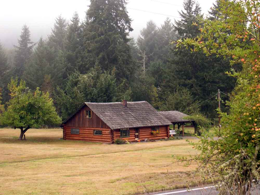
All along this gently descending slope look for outcroppings on the north side of the trail.  This portion of the trail had several trestles as recently as the 1970’s, but they were removed after the development of the County Park at Scaponia. The 1957 DOGAMI report indicates that the fossil beds are exposed for several hundred feet all along this portion of the trail. A short distance past the log cabin the county road and the CZ trail diverge, but before they split there is a gate that connects the two roads. From here it is a short walk along the county road to cross the bridge.  At the west end of the bridge you will find another outcropping on a steep slope about 30 feet above the road.

Site # 4

This site is located near the erstwhile community of Keasey – which now is comprised of one house and a herd of elk. Keasey can be reached by traveling 8 miles from State Avenue and Highway 47 in Vernonia. The outcroppings occur on the banks of Rock Creek. According to the 1957 directions the best sites are located near the trestle that crossed Rock Creek to the Southwest of Keasey, sometimes referred to as Dead Man’s Trestle. The outcroppings occur near the water level on the low bank of Rock Creek, about 8.8 miles from Vernonia.

While this location is not mentioned in any of the trails surveyed, it is along the route that I frequently took to reach the East-side Grade and Rocky Point. If one goes to the gate at the end of the road beyond Keasey, a logging road ascends the east slope of the Rock Creek ravine. This route will eventually bring you to the Rocky Point quarry at the summit (DOGAMI site #5), from whence you can connect with the East-side Grade.

The rail line originally followed Rock Creek all the way to Camp McGregor near the Sunset Highway. However today it is difficult to follow the old rail line since much of this portion of the route was traversed by trestle, and once removed there remained no passable grade to follow. I have descended Rock Creek from above, but even on the west side of the Creek the track is quite obliterated and the terrain is too steep to traverse without significant struggles.

Site # 5

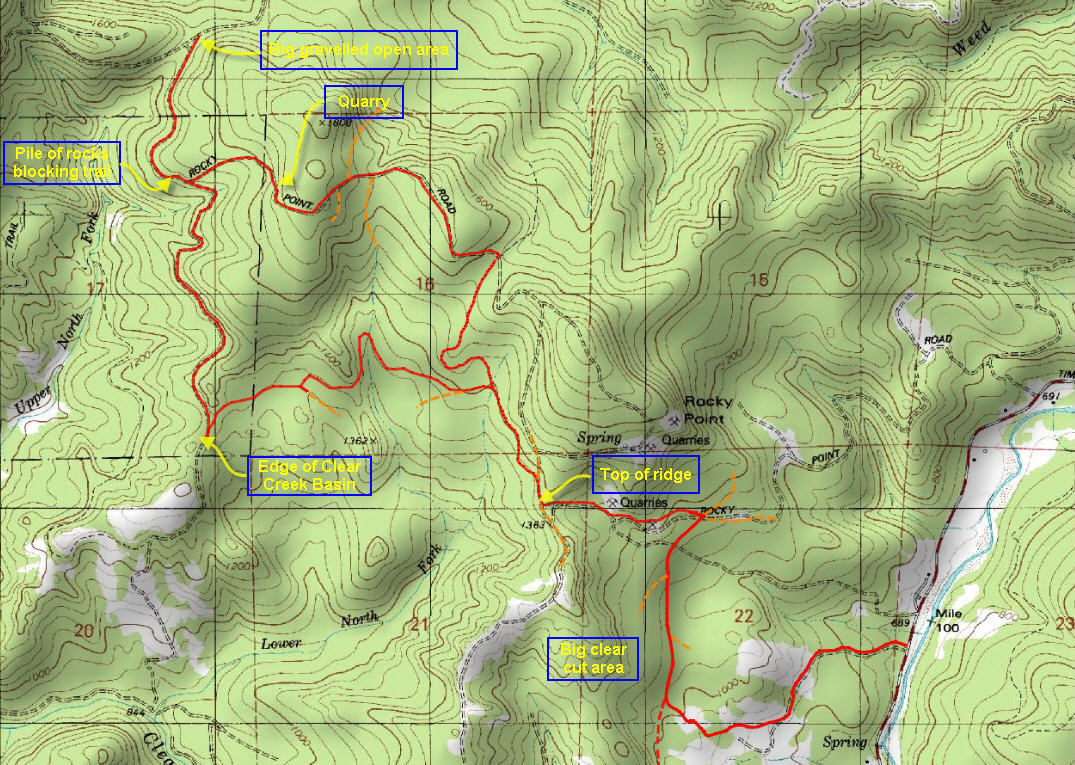
This location is a quarry located on Rocky Point to the west of the Timber Road leading north from the Sunset Highway to Vernonia. From the attached map of the Rocky Point to East Side Grade Trail, you can see that this area has a number of quarries and the description is unclear as to which of these it is. The area can be reached from the Timber road, as described in the “Rocky Point to East Side Grade” trail description.

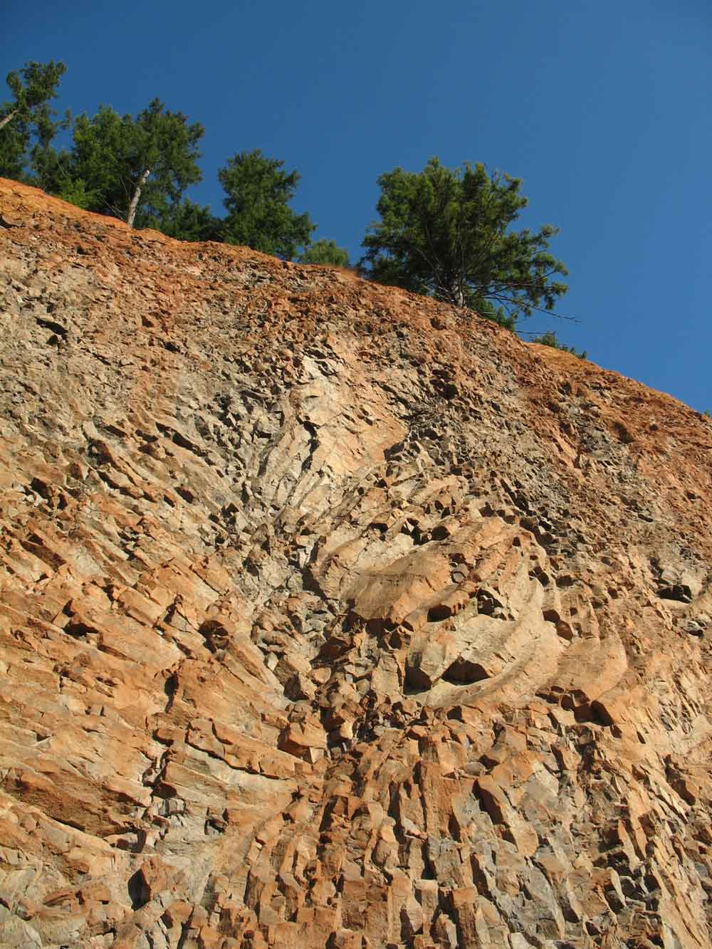
Near the juncture with the East Side Grade is a quarry (marked on the map, as “quarry”) that features a spectacular basalt formation that shows the beauty of the folding that can sometime rearrange the basalt strata into amazing designs.

Site # 6

Another fossiliferous outcropping of the Keasey formation occurs in a prominent cut along the Nehalem River on the east side of the road from Timber to Vernonia, 3 miles north of the junction with the Sunset Highway. Large pelecypods were reportedly found at this site.

Site # 7

Both ends of the Dennis L. Edwards tunnel were originally cited as being good locations to reach the underlying shale beds that contained the fossil-bearing outcroppings, but since it’s the tunnel’s construction in 1940 weathering and grass plantings have degraded the soft shale causing it to disintegrate. In 2002 the tunnel was repaired, and the cuts into the hillside have been further landscaped obscuring the underlying fossil beds.

Site # 8

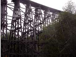
Another location mentioned in the 1957 report is at either end of the high curving rail road trestle that crosses Highway 47 about 6.2 miles north of the Sunset highway. This location is located very close to the Banks to Vernonia trail, which is described in the “Stub Stewart to Trestle” segment of the Banks to Vernonia Trail. According to the DOGAMI report the site is noted for the presence of fossilized crinoids. To reach the outcroppings follow the Banks to Vernonia Trail from the nearby parking lot up the tracks and follow them out to the trestle. Along the way you can locate the fossils in the exposed outcroppings along the tracks.

Site # 9

Further south there are further instances where the Keasey formation is exposed. On the road that connects Timber to the Gales Creek area is an excellent exposed fossil bed. This Keasey formation crops up in a prominent cut at a sharp bend in the Timber-Glenwood road. It is located 1.3 miles south of the railroad crossing in Timber or about 5.2 miles from Glenwood.

Site # 10, 11 and 12

Three further sites are mentioned in Gales Creek area, at a quarry on Scoggins Creek road and finally on the north side of Cherry Grove road. This is also the area of known Indian Petroglyphs along the embankments of the upper Tualatin River, near the Richmond Hill Bridge.

Posted in Geology | 1 Comment